
Source: Bureau of Meteorology
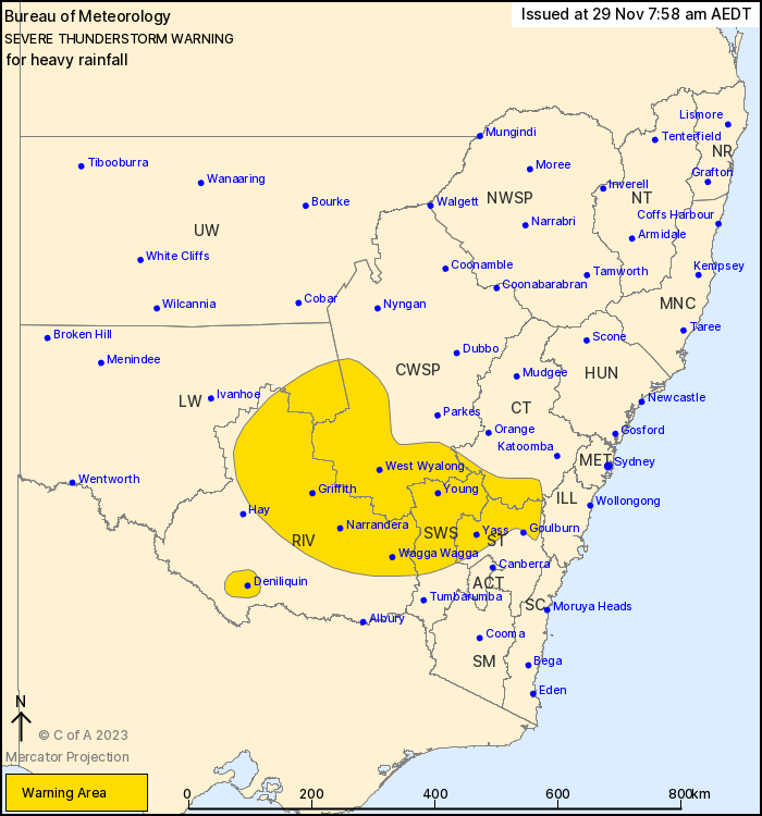
For people in South West Slopes and parts of Central Tablelands,
Southern Tablelands, Central West Slopes and Plains, Riverina and
Lower Western Forecast Districts.
Issued at 7:58 am Wednesday, 29 November 2023.
Severe thunderstorms continuing inland.
Weather Situation: An upper level low over western New South Wales
is maintaining unstable conditions across a large part of the state
this morning. Slow-moving thunderstorm clusters are expected to
continue to develop in a very moist airmass.
Severe thunderstorms are likely to produce heavy rainfall that may
lead to flash flooding in the warning area over the next several
hours. Locations which may be affected include Yass, Wagga Wagga,
West Wyalong, Deniliquin, Griffith and Narrandera.
Heavy rainfall continues in southern parts of the Illawarra and
South Coast, though intense falls have eased in these areas. A
severe weather warning remains current for heavy rainfall in this
area, and if intense falls are detected again, a new severe
thunderstorm warning may be issued again here.
The State Emergency Service advises that people should:
* Keep clear of creeks and storm drains.
* Don't walk, ride your bike or drive through flood water.
* If you are trapped by flash flooding, seek refuge in the highest
available place and ring 000 if you need rescue.
* Be aware that run-off from rainfall in fire affected areas may
behave differently and be more rapid. It may also contain debris
such as ash, soil, trees and rocks.
* After bushfires, heavy rain and the loss of foliage can make the
ground soft and heavy, leading to a greater chance of
landslides.
* Unplug computers and appliances.
* Avoid using the phone during the storm.
* Stay indoors away from windows, and keep children and pets
indoors as well.
* Stay vigilant and monitor conditions. Note that the landscape
may have changed following bushfires.
* For emergency help in floods and storms, ring the SES (NSW and
ACT) on 132 500.
28/Nov/2023 09:13 PM


