
Source: Bureau of Meteorology
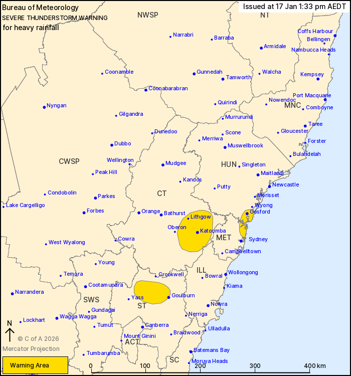
For people in parts of Metropolitan, Central Tablelands, Southern
Tablelands, Hunter and Illawarra Forecast Districts.
Issued at 1:33 pm Saturday, 17 January 2026.
Showers and isolated thunderstorms bring heavy rainfall to North
Sydney, Blue Mountains and Southern Tablelands.
Weather Situation: A trough along central parts of the coast
generates areas of showers and isolated thunderstorms, with some of
these delivering heavy rainfall. Thunderstorms are also expected to
develop this afternoon across northeast parts of the state, and may
also become severe.
Severe thunderstorms are likely to produce heavy rainfall that may
lead to flash flooding in the warning area over the next several
hours. Locations which may be affected include Gosford, Katoomba,
Lithgow, Woy Woy, Jenolan Caves and Springwood.
49mm of rainfall was recorded at Medlow Bath in the 2 hours to
11:30 am.
48mm of rainfall was recorded at Blackheath in the 60 min to 11
am.
35mm of rainfall was recorded at North Parramatta in the 30 min to
8:27 am.
The State Emergency Service advises that people should:
* Keep clear of creeks and storm drains.
* Don't walk, ride your bike or drive through flood water.
* If you are trapped by flash flooding, seek refuge in the highest
available place and ring 000 if you need rescue.
* Stay indoors away from windows, and keep children and pets
indoors as well.
For emergency help in flood and storms, ring the SES on 132
500.
Stay updated on the Hazards Near Me NSW app or the ACT ESA website
(https://esa.act.gov.au).
17/Jan/2026 02:38 AM

