
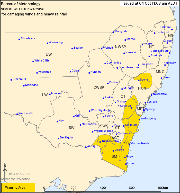
Source: Bureau of Meteorology
For people in Illawarra, South Coast, Snowy Mountains and parts of
Mid North Coast, Hunter, Metropolitan, Central Tablelands, Southern
Tablelands, South West Slopes, Australian Capital Territory, North
West Slopes and Plains and Riverina Forecast Districts.
Issued at 11:08 am Wednesday, 4 October 2023.
Damaging winds over southeastern New South Wales. Possible heavy
rainfall about higher terrain in the south.
Weather situation: Strong northwesterly winds persist over
southern alpine New South Wales this morning ahead of an
approaching cold front and upper trough. This system is expected to
develop into a low pressure system over southern parts of the State
this afternoon and evening. Heavy rain is possible in the south
around this low as it tracks towards the southeast.
Strengthening westerly winds are expected to develop north of the
low across the Great Dividing Range tonight and into
Thursday.
ALPINE PEAKS ABOVE 1900 M: DAMAGING WINDS from the northwest
averaging around 90 km/h are possible over Alpine areas above 1900
m until early Wednesday afternoon.
SOUTHEAST AND CENTRAL PARTS: DAMAGING WIND GUSTS from the west to
northwest with peak gusts in excess of 90 km/h are expected to
develop across central and southern ranges and coastal parts of the
Illawarra and South Coast from early Thursday morning. Winds should
broadly ease by midday on Thursday, though they could persist into
early afternoon for the far southeast of the State.
HEAVY RAINFALL which may lead to FLASH FLOODING is forecast for
parts of the Southwest Slopes, ACT, Snowy Mountains and South Coast
districts during Wednesday evening as the low pressure system
consolidates. Six-hourly rainfall totals between 50 to 80 mm are
possible, with 24-hourly rainfall totals of 80 to 100 mm
possible.
Flood watches are current for southeastern catchments. Please
refer to http://www.bom.gov.au/nsw/warnings/
Locations which may be affected include Nowra, Eden, Bega,
Katoomba, Cooma, Albury and Hay.
Significant wind observations in the 24 hours to 11:00 AM AEDT
Wednesday include:
126 km/h recorded at Thredbo
93 km/h at Mt Ginini
The State Emergency Service advises that people should:
* Move vehicles under cover or away from trees.
* Secure or put away loose items around your house, yard and
balcony.
* Keep at least 8 metres away from fallen power lines or objects
that may be energised, such as fences.
* Trees that have been damaged by fire are likely to be more
unstable and more likely to fall.
* Report fallen power lines to either Ausgrid (131 388), Endeavour
Energy (131 003), Essential Energy (132 080) or Evoenergy (131 093)
as shown on your power bill.
* Don't drive, ride or walk through flood water.
* Keep clear of creeks and storm drains.
* If you are trapped by flash flooding, seek refuge in the highest
available place and ring 000 if you need rescue.
* Be aware that run-off from rainfall in fire affected areas may
behave differently and be more rapid. It may also contain debris
such as ash, soil, trees and rocks.
* After bushfires, heavy rain and the loss of foliage can make the
ground soft and heavy, leading to a greater chance of
landslides.
* Stay vigilant and monitor conditions. Note that the landscape
may have changed following bushfires.
* For emergency help in floods and storms, ring your local SES
Unit on 132 500.
04/Oct/2023 12:26 AM

