
Source: Bureau of Meteorology
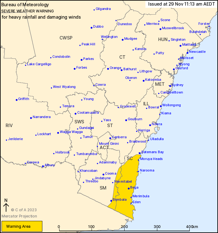
For people in South Coast and parts of Snowy Mountains Forecast
Districts.
Issued at 11:13 am Wednesday, 29 November 2023.
Heavy to intense rainfall south of Batemans Bay persisting during
Wednesday.
Weather Situation: A broad low pressure system over southern
inland New South Wales is moving slowly towards the southeast,
developing in response to a strong upper level low over the west of
the state. A trough is deepening down the southern coastline today,
drawing in rich moisture from the Tasman Sea. Persistent heavy
rainfall with some embedded heavier showers and thunderstorms for
the South Coast, with strong winds affecting the coastal
fringe.
HEAVY RAINFALL which may lead to FLASH FLOODING is currently
occurring across broad areas of the South Coast and the far east of
the Snowy Mountains districts, and is expected to persist
throughout Wednesday. Six-hourly rainfall totals of 60 to 120 mm
are likely, with isolated intense falls of up to 180 mm possible.
24-hourly totals of 150 to 200 mm are likely, with isolated falls
in excess of 300 mm possible, particularly for areas south of
Moruya.
Transient areas of INTENSE RAINFALL have been observed this
morning, and remain possible during Wednesday. A separate severe
thunderstorm warning will be issued to highlight these areas when
they occur.
DAMAGING WINDS averaging 60 to 70 km/h with peak gusts of around
90 km/h are possible along the coastal fringe south of Moruya
Heads.
The broad severe weather risk should begin to contract towards the
southern half of the South Coast this afternoon, though heavy
showers and thunderstorms will remain possible throughout the day.
The far south of the South Coast may see continued heavy rain well
into Thursday, though there is uncertainty on this due to the
movement and positioning of the low and trough.
Several flood watches and warnings are also current for these
areas. Please refer to http://www.bom.gov.au/nsw/warnings/
Locations which may be affected include Eden, Bega, Moruya Heads,
Narooma and Merimbula.
Severe weather is no longer occurring in the Illawarra district
and the warning for this district is CANCELLED.
Recent 6-hour rainfall totals include:
128 mm at Brogo Dam
120 mm at Point Perpendicular
109 mm at Lochiel
100 mm at Moruya
84 mm at Bega
Montague Island Lighthouse observed a 120 km/h gust at
11:00am
Green Cape observed a wind gust of 100 km/h at 10:57am
The State Emergency Service advises that people should:
* Move vehicles under cover or away from trees.
* Secure or put away loose items around your house, yard and
balcony.
* Keep at least 8 metres away from fallen power lines or objects
that may be energised, such as fences.
* Trees that have been damaged by fire are likely to be more
unstable and more likely to fall.
* Report fallen power lines to either Ausgrid (131 388), Endeavour
Energy (131 003), Essential Energy (132 080) or Evoenergy (131 093)
as shown on your power bill.
* Don't drive, ride or walk through flood water.
* Keep clear of creeks and storm drains.
* If you are trapped by flash flooding, seek refuge in the highest
available place and ring 000 if you need rescue.
* Be aware that run-off from rainfall in fire affected areas may
behave differently and be more rapid. It may also contain debris
such as ash, soil, trees and rocks.
* After bushfires, heavy rain and the loss of foliage can make the
ground soft and heavy, leading to a greater chance of
landslides.
* Stay vigilant and monitor conditions. Note that the landscape
may have changed following bushfires.
* For emergency help in floods and storms, ring your local SES
Unit on 132 500.
29/Nov/2023 12:27 AM

