
Source: Bureau of Meteorology
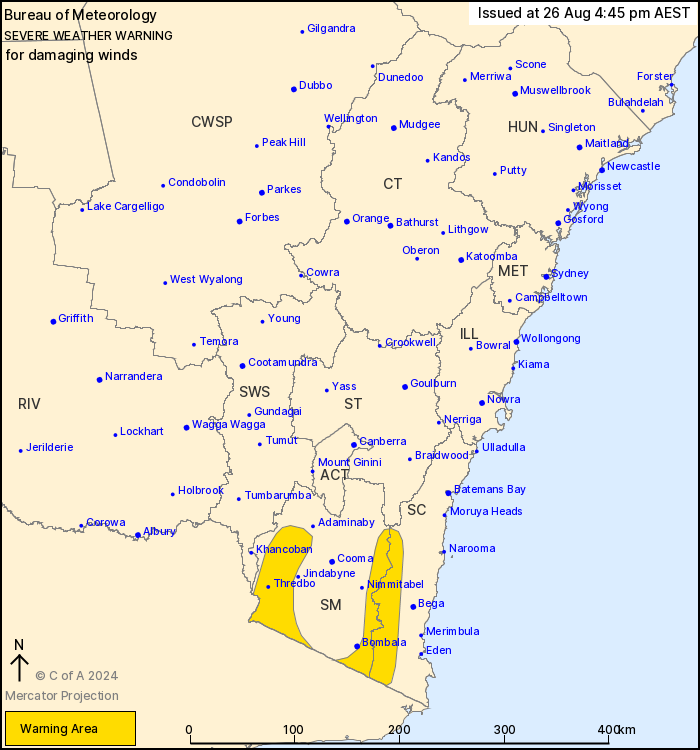
For people in parts of South Coast and Snowy Mountains Forecast
Districts.
Issued at 4:45 pm Monday, 26 August 2024.
Damaging winds developing over alpine and elevated parts from
Tuesday evening.
Weather Situation: A strong cold front will move into Victoria on
Tuesday afternoon, with a strong northwesterly pressure gradient
across the southeast of NSW building ahead of it. The front will
move into NSW on Wednesday, with winds turning westerly behind
it.
For ALPINE PEAKS above 1900M: DAMAGING WINDS averaging 80 to 90
km/h with peak gusts of around 125 km/h are possible over alpine
areas from Tuesday evening, easing from Wednesday afternoon.
For ELEVATED PARTS AND SLOPES OF THE SNOWY MOUNTAINS AND THE SOUTH
COAST: DAMAGING WINDS averaging 60 to 70 km/h with peak gusts of
around 100 km/h are likely from Tuesday evening, easing by
Wednesday afternoon.
Locations which may be affected include Perisher Valley, Charlotte
Pass and Thredbo Top Station.
The State Emergency Service advises that people should:
* Move vehicles under cover or away from trees.
* Secure or put away loose items around your house, yard and
balcony.
* Keep at least 8 metres away from fallen power lines or objects
that may be energised, such as fences.
* Trees that have been damaged by fire are likely to be more
unstable and more likely to fall.
* Report fallen power lines to either Ausgrid (131 388), Endeavour
Energy (131 003), Essential Energy (132 080) or Evoenergy (131 093)
as shown on your power bill.
* Stay vigilant and monitor conditions. Note that the landscape
may have changed following bushfires.
* For emergency help in floods and storms, ring your local SES
Unit on 132 500.
26/Aug/2024 06:56 AM

