
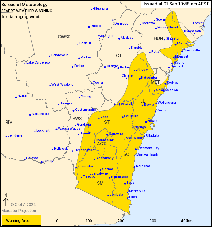
Source: Bureau of Meteorology
For people in Illawarra, South Coast, Southern Tablelands, Snowy
Mountains, Australian Capital Territory and parts of Hunter,
Metropolitan, Central Tablelands, South West Slopes and Mid North
Coast Forecast Districts.
Issued at 10:48 am Sunday, 1 September 2024.
Damaging winds over parts of southeast NSW today, increasing
Monday.
Weather Situation: A strong westerly flow over southeast Australia
will peak over NSW and ACT as an embedded low moves through Bass
Strait early Monday and an associated front crosses southern parts
of NSW Monday morning.
For the SNOWY MOUNTAINS, the ACT, southwestern parts of the
SOUTHERN TABLELANDS and adjacent parts of the SOUTHWEST SLOPES:
DAMAGING WINDS averaging 60 to 70 km/h with peak gusts up to 100
km/h are possible today and Monday, although generally limited to
areas above 700m elevation during Sunday. These winds become more
likely during Monday morning including possibly affecting Canberra.
Wind gusts to 120 km/h are possible during Monday morning to early
afternoon over higher elevations.
For areas above 1900m DAMAGING WINDS may average 80 to 90 km/h
with peak gusts in excess of 110 km/h possible today and Monday.
Wind gusts in excess of 125km/h are possible from early Monday
through to around midday Monday.
For elevations above 500m of the ILLAWARRA, CENTRAL AND SOUTHERN
TABLELANDS, BLUE MOUNTAINS and SOUTH COAST: DAMAGING WINDS
averaging 60 to 70 km/h with peak gusts of around 100 km/h are
possible throughout today and Monday. The main risk periods are
through to late afternoon today, and again during Monday. Possible
gusts to 120km/h during the Monday morning period.
For the SYDNEY METROPOLITAN and HUNTER, as well as all remaining
lower elevations and coastal locations of the warning area:
DAMAGING WINDS averaging 60 to 70 km/h with peak gusts of around
100 km/h are possible during Monday with the peak of the risk from
mid-morning through till mid afternoon, or with showers in the
south.
The risk of damaging winds is expected to become confined to
higher elevations in the south by Monday evening.
Locations which may be affected include Newcastle, Sydney,
Wollongong, Nowra, Batemans Bay, Canberra and Goulburn.
Significant observations in the past 12 hours to 10:30 am AEST
Sunday include:
Sustained 81 km/h winds with 120 km/h gusts at Thredbo at
10:24am
Sustained 63 km/h winds at Nerriga at 9:29am
The State Emergency Service advises that people should:
* Move vehicles under cover or away from trees.
* Secure or put away loose items around your house, yard and
balcony.
* Keep at least 8 metres away from fallen power lines or objects
that may be energised, such as fences.
* Trees that have been damaged by fire are likely to be more
unstable and more likely to fall.
* Report fallen power lines to either Ausgrid (131 388), Endeavour
Energy (131 003), Essential Energy (132 080) or Evoenergy (131 093)
as shown on your power bill.
* Stay vigilant and monitor conditions. Note that the landscape
may have changed following bushfires.
* For emergency help in floods and storms, ring your local SES
Unit on 132 500.
01/Sep/2024 01:03 AM

