
Source: Bureau of Meteorology
For people in parts of Illawarra, South Coast, Southern
Tablelands, South West Slopes and Snowy Mountains Forecast
Districts.
Issued at 4:42 am Saturday, 29 March 2025.
Heavy rainfall and damaging wind gusts to develop over the
southeast from Saturday evening.
Weather Situation: An upper trough will move through eastern parts
of New South Wales today, with a low pressure system forecast to
develop and deepen off the southeast coast Saturday evening. This
will strengthen southeasterly winds along the coast and also across
the Snowy Mountains, and enhance rainfall in coastal areas. The low
is then forecast to move further offshore during Sunday
evening.
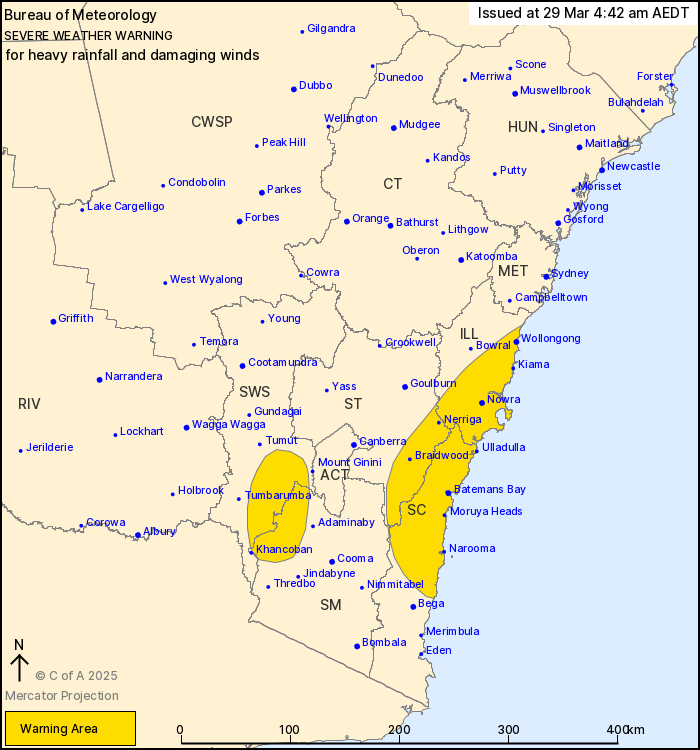
For the SOUTHERN RANGES AND ADJACENT COASTLINE:
HEAVY RAINFALL which may lead to FLASH FLOODING is forecast to
develop over the South Coast and Illawarra districts during
Saturday evening, before extending to eastern parts of the Southern
Tablelands district by early Sunday morning. Six-hourly rainfall
totals between 50 to 90 mm are possible, with isolated falls around
110 mm possible. 24-hourly rainfall totals between 60 to 110 mm are
possible, with isolated falls around 140 mm possible. Heavy
rainfall is forecast to ease by late Sunday morning.
Strong south to southwesterly winds averaging 60 to 70 km/h with
DAMAGING WIND GUSTS around 90 km/h are possible about the coastal
fringe of the South Coast and Illawarra districts between Narooma
and Bellambi from late Saturday evening, contracting north out of
the South Coast district during Sunday morning.
For the SNOWY MOUNTAINS: Strong southeasterly winds averaging 50
to 60 km/h with DAMAGING WIND GUSTS around 100 km/h are possible
for parts of the Snowy Mountains during Saturday evening. Damaging
winds are forecast to ease over the Snowy Mountains during Sunday
morning.
Locations which may be affected include Wollongong, Nowra,
Batemans Bay, Braidwood, Moruya Heads and Selwyn.
The State Emergency Service advises that people should:
* Don't drive, ride or walk through flood water.
* Keep clear of creeks and storm drains.
* If you are trapped by flash flooding, seek refuge in the highest
available place and ring 000 if you need rescue.
* Be aware that run-off from rainfall in fire affected areas may
behave differently and be more rapid. It may also contain debris
such as ash, soil, trees and rocks.
* After bushfires, heavy rain and the loss of foliage can make the
ground soft and heavy, leading to a greater chance of
landslides.
* Move vehicles under cover or away from trees.
* Secure or put away loose items around your house, yard and
balcony.
* Keep at least 8 metres away from fallen power lines or objects
that may be energised, such as fences.
* Trees that have been damaged by fire are likely to be more
unstable and more likely to fall.
* Report fallen power lines to either Ausgrid (131 388), Endeavour
Energy (131 003), Essential Energy (132 080) or Evoenergy (131 093)
as shown on your power bill.
* Stay vigilant and monitor conditions. Note that the landscape
may have changed following bushfires.
* For emergency help in floods and storms, ring your local SES
Unit on 132 500.
28/Mar/2025 08:54 PM

