
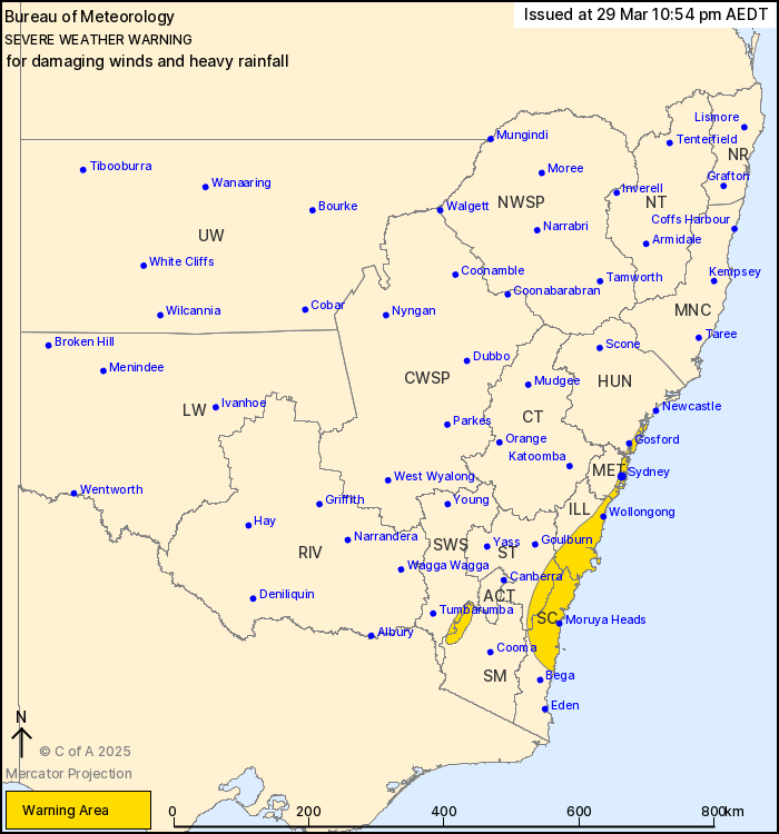
Source: Bureau of Meteorology
For people in parts of Metropolitan, Illawarra, South Coast,
Southern Tablelands, Snowy Mountains, Hunter and South West Slopes
Forecast Districts.
Issued at 10:54 pm Saturday, 29 March 2025.
Damaging wind gusts and possible heavy rainfall about parts of
southeast and central eastern NSW overnight into Sunday.
Weather Situation: An upper trough is moving through eastern parts
of New South Wales and will aid in the development of a low
pressure system off the Illawarra coast overnight and Sunday
morning. This low will generate strong winds and a small risk of
heavy rainfall over its southern and western portions, affecting
the southern and central coast and adjacent inland. The low is then
forecast to move further offshore later Sunday, with conditions
easing.
For the COASTAL DISTRICTS AND ADJACENT COASTAL RANGES:
Strong south to southwesterly winds averaging 60 to 65 km/h with
DAMAGING WIND GUSTS around 90 km/h are possible about the coastal
fringe of the South Coast and Illawarra districts between Narooma
and Bellambi, extending along the Sydney coastal fringe early
Sunday morning, and the Central Coast during Sunday plus eastern
parts of the Southern Tablelands.
Winds are expected to ease along South Coast during Sunday, below
warning threshold south of Batemans Bay during Sunday
morning.
A small risk of HEAVY RAINFALL which may lead to FLASH FLOODING
will remain over northern parts of the South Coast and southern
Illawarra districts for the next few hours. Three-hourly rainfall
totals between 40 to 50 mm are possible, with potential isolated
falls around 80 mm. The heavy rainfall risk will end early Sunday
morning.
Locations which may be affected include Sydney, Wollongong, Nowra,
Batemans Bay, Braidwood, Moruya Heads, Kiama, Huskisson, Ulladulla,
Narooma, Araluen and Nerriga.
For the SNOWY MOUNTAINS:
Strong southeasterly winds averaging 50 to 60 km/h with DAMAGING
WIND GUSTS around 100 km/h are possible for parts of the Snowy
Mountains during Saturday evening, then forecast to ease during
Sunday morning.
Locations which may be affected include Sydney, Wollongong, Nowra,
Batemans Bay, Braidwood and Moruya Heads.
For the SNOWY MOUNTAINS:
Strong southeasterly winds averaging 50 to 60 km/h with DAMAGING
WIND GUSTS around 100 km/h are possible for parts of the Snowy
Mountains during Saturday evening, then forecast to ease during
Sunday morning.
Locations which may be affected include Cabramurra and
Selwyn.
A 93 km/h wind gust was recorded at Kiama (Bombo Headland) at
10:44 pm
A 93 km/h wind gust was recorded at Point Perpendicular at 10:21
pm
A COASTAL HAZARDS warning is current for parts of the NSW coast.
FLOOD WATCHES and WARNINGS are also in place for many NSW
catchments. For details, visit
http://www.bom.gov.au/nsw/warnings/.
The State Emergency Service advises that people should:
* Don't drive, ride or walk through flood water.
* Keep clear of creeks and storm drains.
* If you are trapped by flash flooding, seek refuge in the highest
available place and ring 000 if you need rescue.
* Be aware that run-off from rainfall in fire affected areas may
behave differently and be more rapid. It may also contain debris
such as ash, soil, trees and rocks.
* After bushfires, heavy rain and the loss of foliage can make the
ground soft and heavy, leading to a greater chance of
landslides.
* Move vehicles under cover or away from trees.
* Secure or put away loose items around your house, yard and
balcony.
* Keep at least 8 metres away from fallen power lines or objects
that may be energised, such as fences.
* Trees that have been damaged by fire are likely to be more
unstable and more likely to fall.
* Report fallen power lines to either Ausgrid (131 388), Endeavour
Energy (131 003), Essential Energy (132 080) or Evoenergy (131 093)
as shown on your power bill.
* Stay vigilant and monitor conditions. Note that the landscape
may have changed following bushfires.
* For emergency help in floods and storms, ring your local SES
Unit on 132 500.
29/Mar/2025 12:15 PM

