
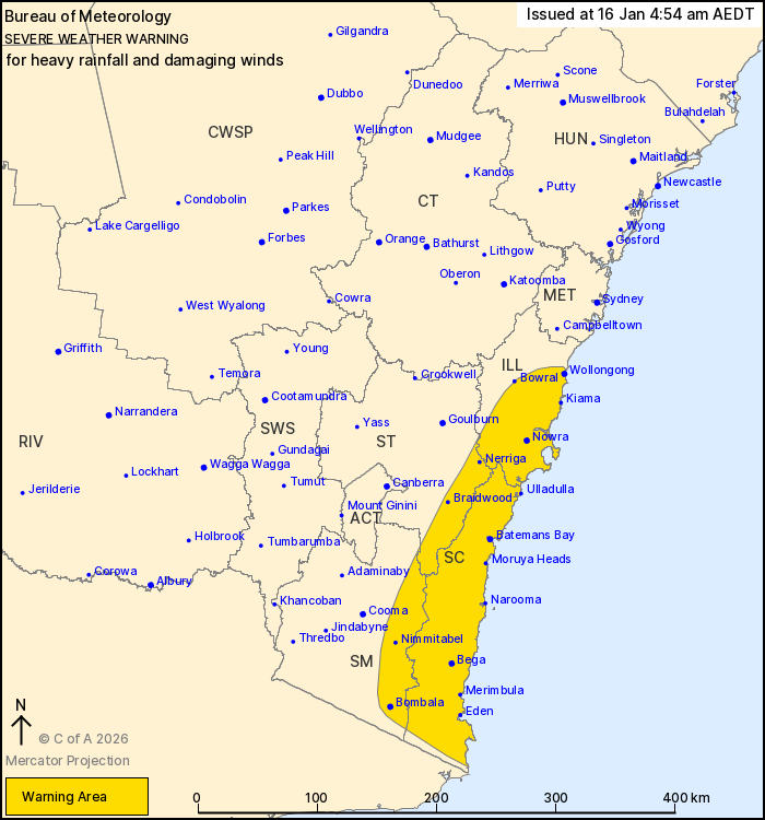
Source: Bureau of Meteorology
For people in South Coast and parts of Illawarra, Southern
Tablelands and Snowy Mountains Forecast Districts.
Issued at 4:54 am Friday, 16 January 2026.
Heavy rainfall and damaging winds are possible in the southeast
today.
Weather Situation: A coastal trough is developing just off the
south coast this morning, and is expected to direct areas of heavy
rain and damaging south to southeasterly winds over southeastern
parts of the state today.
HEAVY RAINFALL which may lead to FLASH FLOODING is possible over
parts of the South Coast this morning, with this risk spreading to
parts of the Illawarra from later in the morning. Six-hourly
rainfall totals between 50 and 80 mm are likely, and isolated
totals up to 120 mm are possible.
DAMAGING WINDS, averaging 60 to 70 km/h with peak gusts of around
100 km/h are possible about parts of the southeast from later this
morning.
A separate warning for DAMAGING SURF is current for coastal
locations between Eden and Ulladulla.
Locations which may be affected include Wollongong, Nowra,
Batemans Bay, Eden, Braidwood and Bega.
The State Emergency Service advises that people should:
* Park your car under secure cover and away from trees, powerlines
and drains.
* Secure or put away loose items around your house, yard and
balcony.
* Keep at least 8 metres away from fallen power lines or objects
that may be energised, such as fences.
* Report fallen power lines to either Ausgrid (131 388), Endeavour
Energy (131 003), Essential Energy (132 080) or Evoenergy (131 093)
as shown on your power bill.
* Don't drive, ride or walk through flood water.
* Keep clear of creeks and storm drains.
* If you are trapped by flash flooding, seek refuge in the highest
available place and ring 000 if you need rescue.
For emergency help in flood and storms, ring the SES on 132
500.
Stay updated on the Hazards Near Me NSW app or the ACT ESA website
(https://esa.act.gov.au).
15/Jan/2026 07:33 PM

