
Source: Bureau of Meteorology
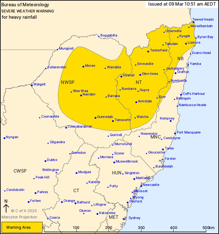
For people in Northern Rivers, Northern Tablelands and parts of
Mid North Coast and North West Slopes and Plains Forecast
Districts.
Issued at 10:51 am Sunday, 9 March 2025.
Heavy rainfall is forecast over northeastern NSW today and into
Monday morning.
Weather Situation: Ex-Tropical Cyclone Alfred made landfall over
the southeast Queensland coastline on Saturday evening and is
continuing to weaken as it moves further inland this morning. Heavy
rainfall is still possible over parts of the Northern Rivers,
Northern Tablelands and Mid North Coast today and extending into
the Northwest Slopes and Plains Monday, before easing Monday
afternoon.
HEAVY RAINFALL which may lead to FLASH FLOODING is possible today
about parts of the Northern Rivers, Mid North Coast and eastern
parts of the Northern Tablelands extending into the Northwest
Slopes and Plains after midnight and throughout Monday morning.
Six-hourly rainfall totals between 50 and 100 mm are possible.
24-hourly rainfall totals between 100 and 150 mm are
possible.
Heavy rainfall is forecast to ease during Monday afternoon.
The risk of damaging wind gusts has eased throughout the warning
area.
A Flood Watch and Flood Warnings are current for New South
Wales.
For these products, please refer to:
http://www.bom.gov.au/australia/warnings/
Locations which may be affected include Lismore, Armidale,
Tenterfield, Tamworth, Gunnedah, Moree, Narrabri, Casino and
Kyogle.
The State Emergency Service advises that people should:
* Don't drive, ride or walk through flood water.
* Keep clear of creeks and storm drains.
* If you are trapped by flash flooding, seek refuge in the highest
available place and ring 000 if you need rescue.
* Be aware that run-off from rainfall in fire affected areas may
behave differently and be more rapid. It may also contain debris
such as ash, soil, trees and rocks.
* After bushfires, heavy rain and the loss of foliage can make the
ground soft and heavy, leading to a greater chance of
landslides.
* Stay vigilant and monitor conditions. Note that the landscape
may have changed following bushfires.
* For emergency help in floods and storms, ring your local SES
Unit on 132 500.
09/Mar/2025 02:43 AM

