
Source: Bureau of Meteorology
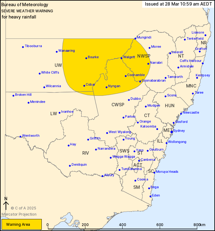
For people in parts of North West Slopes and Plains, Central West
Slopes and Plains, Upper Western and Lower Western Forecast
Districts.
Issued at 10:59 am Friday, 28 March 2025.
Moderate to heavy rainfall continues to develop about northwestern
New South Wales today.
Weather Situation: A trough and upper disturbance that brought
widespread heavy rainfall to parts of inland Queensland will dip
southwards into northern inland parts of the state today, before
tracking into eastern districts over the weekend.
Moderate to HEAVY RAINFALL which may lead to FLASH FLOODING may
develop about parts of the Upper Western this morning, extending to
the northern reaches of the Central West Slopes and Plains and
adjacent districts this afternoon. Six-hourly rainfall totals
between 30 and 50 mm are likely, with isolated falls of up to 75 mm
possible. 24-hourly rainfall totals of between 50 to 100 mm are
likely, with isolated totals of up to 130 mm possible.
Locations which may be affected include Narrabri, Walgett, Cobar,
Bourke, Lightning Ridge and Brewarrina.
The State Emergency Service advises that people should:
* Don't drive, ride or walk through flood water.
* Keep clear of creeks and storm drains.
* If you are trapped by flash flooding, seek refuge in the highest
available place and ring 000 if you need rescue.
* Be aware that run-off from rainfall in fire affected areas may
behave differently and be more rapid. It may also contain debris
such as ash, soil, trees and rocks.
* After bushfires, heavy rain and the loss of foliage can make the
ground soft and heavy, leading to a greater chance of
landslides.
* Stay vigilant and monitor conditions. Note that the landscape
may have changed following bushfires.
* For emergency help in floods and storms, ring your local SES
Unit on 132 500.
28/Mar/2025 12:04 AM

