
Source: Bureau of Meteorology
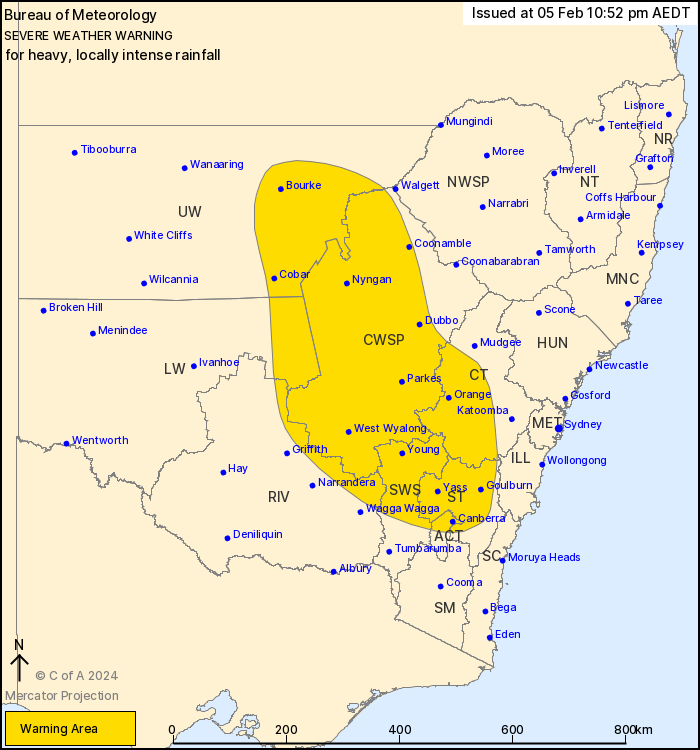
For people in Southern Tablelands, Central West Slopes and Plains,
South West Slopes and parts of Central Tablelands, Riverina, Lower
Western, Upper Western and Australian Capital Territory Forecast
Districts.
Issued at 10:52 pm Monday, 5 February 2024.
HEAVY, LOCALLY INTENSE RAINFALL EXTENDING TO SOUTHERN AND CENTRAL
RANGES OVERNIGHT.
Weather Situation: Ex-Tropical Cyclone Kirrily is currently
centred near Bourke and is expected to move southeastwards and
gradually weaken during Monday night. The system and its associated
severe weather are expected to clear New South Wales by Tuesday
afternoon.
HEAVY RAINFALL which may lead to FLASH FLOODING is expected in the
northwest this afternoon and evening, extending to the southern and
central ranges overnight. Six-hourly rainfall totals between 50 and
80 mm are likely, with 24-hourly totals between 70 and 100 mm
likely.
Locally INTENSE RAINFALL which may lead to DANGEROUS AND
LIFE-THREATENING FLASH FLOODING is also possible west of Parkes
tonight, easing early Tuesday morning. Isolated six-hourly totals
between 80 and 120 mm are possible, with 24-hourly totals up to 150
mm possible. A separate Severe Thunderstorm Warning will be issued
if VERY DANGEROUS THUNDERSTORMS with INTENSE RAINFALL are
detected.
Heavy rainfall is expected ease below warning thresholds by
Tuesday afternoon.
A Flood Watch is also current for the Far West and South West
catchments. See http://www.bom.gov.au/nsw/warnings/ for more
information.
Locations which may be affected include Orange, Canberra,
Goulburn, Dubbo, Cobar and Bourke.
85 mm was recorded at White Cliffs in 6 hours to 1:32 pm.
75 mm was recorded at Wanaaring (Borrona Downs) in 6 hours to 2:41
pm.
73 mm was recorded at Killala in 6hrs to 10:31 pm.
61 mm was recorded at Girilambone (Okeh) in 3hrs to 10:32
pm.
The State Emergency Service advises that people should:
* Don't drive, ride or walk through flood water.
* Keep clear of creeks and storm drains.
* If you are trapped by flash flooding, seek refuge in the highest
available place and ring 000 if you need rescue.
* Be aware that run-off from rainfall in fire affected areas may
behave differently and be more rapid. It may also contain debris
such as ash, soil, trees and rocks.
* After bushfires, heavy rain and the loss of foliage can make the
ground soft and heavy, leading to a greater chance of
landslides.
* Stay vigilant and monitor conditions. Note that the landscape
may have changed following bushfires.
* For emergency help in floods and storms, ring your local SES
Unit on 132 500.
05/Feb/2024 12:10 PM


