
Source: Bureau of Meteorology
Issued at 7:44 pm EST on Wednesday 5 March 2025
Headline:
Impacts from Tropical Cyclone Alfred increasing for southeast
Queensland and northeast New South Wales overnight.
Areas Affected:
Warning Zone
Double Island Point in Queensland to Grafton in New South Wales,
including Brisbane, Gold Coast, Sunshine Coast, Byron Bay and
Ballina but not including Grafton.
Watch Zone
None.
Cancelled Zone
None.
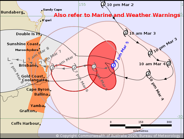
Details of Tropical Cyclone Alfred 22U at 7:00 pm AEST [8:00 pm
AEDT]:
Intensity: Category 2, sustained winds near the centre of 95
kilometres per hour with wind gusts to 130 kilometres per
hour.
Location: within 30 kilometres of 27.4 degrees South 156.7 degrees
East, estimated to be 365 kilometres east of Brisbane and 340
kilometres east northeast of Gold Coast.
Movement: northwest at 7 kilometres per hour.
Tropical Cyclone Alfred will continue its approach towards the
southeast Queensland coast tonight, with the far western edge
already impacting the coast from about Coolangatta to
Ballina.
Alfred is a category 2 cyclone, and is forecast to maintain this
intensity as it continues to approach the southeast Queensland
coast. The centre of Alfred is expected to cross the coast during
Friday, noting that latest weather model data indicates the
potential for a later crossing time than previously indicated.
Location of crossing still remains most likely between Maroochydore
and Coolangatta.
Hazards:
Gales with DAMAGING WIND GUSTS to 120 kilometres per hour are
developing near the coast from Coolangatta to Ballina. Gales with
DAMAGING WIND GUSTS to 120 kilometres per hour are expected to
develop along the remaining southeast Queensland and northeastern
New South Wales coastal and island communities between Double
Island Point and Grafton overnight and during Thursday morning,
persisting through Friday.
DESTRUCTIVE WIND GUSTS of up to 155 kilometres per hour may
develop about coastal and island locations near and to the south of
the track, possibly as far south as about Cape Byron, late Thursday
or early Friday as Alfred's destructive core approaches and crosses
the coast. DESTRUCTIVE WIND GUSTS may extend to the mainland areas
close to the centre during Friday.
A DANGEROUS STORM TIDE is likely along the coastal foreshore for
exposed areas near and south of the cyclone centre, possible as far
south as Cape Byron, if the time of coastal crossing coincides with
the high tide. Tides are likely to rise significantly above the
highest high tide mark with damaging waves and dangerous inundation
of coastal low-lying areas.
There is a possibility that DANGEROUSLY HIGH TIDES could cause
further coastal erosion and some inundation of low-lying areas near
exposed beaches on the Gold Coast, including to the NSW/Qld border
and the Tweed Coast. This is dependent on how Alfred behaves as it
approaches the coast.
ABNORMALLY HIGH TIDES are likely to continue causing MINOR
FLOODING of coastal low lying areas between Double Island Point and
Grafton, particularly during the time of high tides early Thursday
morning (Wednesday night), early Friday morning (Thursday night)
and early Saturday morning (Friday night). DAMAGING SURF leading to
significant beach erosion remains likely for the open beaches
between Double Island Point and Grafton, and further south over the
New South Wales coast. Separate Coastal Hazard and Hazardous Surf
Warning are current for southeast Queensland and northeastern New
South Wales coasts.
HEAVY RAINFALL may develop for southeast Queensland and
northeastern New South Wales from Thursday. HEAVY to locally
INTENSE RAINFALL which may lead to DANGEROUS AND LIFE-THREATENING
FLASH FLOODING may occur near and south of the cyclone centre as
Alfred approaches and crosses the coast. Separate Severe Weather
Warning and Flood Watch are current for southeast Queensland and
northeast New South Wales.
Refer to associated warnings for Queensland and New South Wales at
http://www.bom.gov.au/australia/warnings.
Recommended Action:
People between Double Island Point in Queensland and Grafton in
New South Wales should immediately commence or continue
preparations, especially securing boats and property.
- For cyclone preparedness and safety advice, visit the Get Ready
Queensland website (www.getready.qld.gov.au)
- If you choose to take shelter away from your home, stay COVID-19
safe and pack a mask and hand sanitiser (if you have them).
- For emergency assistance call the Queensland State Emergency
Service or New South Wales State Emergency Service (SES) on 132 500
(for assistance with storm damage, rising flood water, fallen trees
on buildings or roof damage).
Current
Tropical Cyclones
05/Mar/2025 10:06 AM

