
Source: Bureau of Meteorology
Issued at 10:54 am EST on Monday 3 March 2025
Headline:
Tropical Cyclone Alfred is expected to move towards the southeast
Queensland coast from Tuesday onwards.
Areas Affected:
Warning Zone
None.
Watch Zone
Sandy Cape to Grafton including Brisbane, Gold Coast, Sunshine
Coast and Byron Bay but not including Grafton..
Cancelled Zone
None.
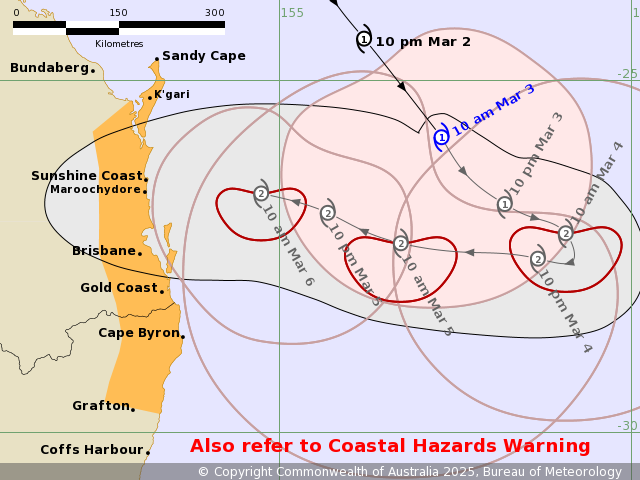
Details of Tropical Cyclone Alfred 22U at 10:00 am AEST [9:30 am
ACST]:
Intensity: Category 1, sustained winds near the centre of 85
kilometres per hour with wind gusts to 120 kilometres per
hour.
Location: within 35 kilometres of 25.8 degrees South 157.3 degrees
East, estimated to be 465 kilometres east northeast of Brisbane and
430 kilometres east northeast of Maroochydore.
Movement: southeast at 20 kilometres per hour.
Tropical Cyclone Alfred will continue moving towards the southeast
today, slightly away from the Queensland coast before slowing down
and turning westward, towards the Queensland coast on
Tuesday.
Alfred is currently a category 1 cyclone but is expected to
intensify to a category 2 cyclone tonight. It is likely to maintain
a category 2 intensity as it approaches the southeast Queensland
coast late on Thursday.
Hazards:
Severe coastal hazards, including abnormally high tides and
hazardous surf are expected to continue over southern Queensland
and northeastern New South Wales coasts, deteriorating further as
Alfred begins to move towards the coast from Tuesday onwards. A
large and powerful to potentially damaging easterly swell is
occurring about exposed southern Queensland beaches, and is
forecast to extend to northern New South Wales coast today.
Gales with DAMAGING WIND GUSTS to 120 kilometres per hour are
expected to develop along the southeast Queensland and northeastern
New South Wales coastal and island communities between Tewantin and
Grafton during Wednesday. Gales may extend north to Sandy Cape from
late Wednesday onwards.
Heavy rainfall is forecast for southeast Queensland and
northeastern New South Wales from Wednesday as Alfred approaches
the coast. HEAVY to locally INTENSE RAINFALL which may lead to
DANGEROUS AND LIFE-THREATENING FLASH FLOODING near and south of the
system centre as Alfred approaches and crosses the coast late on
Thursday. Flood Watches have been issued for these areas.
Refer to associated warnings for Queensland and New South Wales at
http://www.bom.gov.au/australia/warnings.
Recommended Action:
People between Sandy Cape in Queensland and Grafton in New South
Wales should consider what action they will need to take if the
cyclone threat increases.
- Information is available from your local government
- For cyclone preparedness and safety advice, visit the Get Ready
Queensland website (www.getready.qld.gov.au)
- For emergency assistance call the Queensland or New South Wales
State Emergency Service (SES) on 132 500 (for assistance with storm
damage, rising flood water, fallen trees on buildings or roof
damage).
Current
Tropical Cyclones
03/Mar/2025 01:10 AM

