
Source: Bureau of Meteorology
Issued at 10:45 am EST on Tuesday 4 March 2025
Headline:
Tropical Cyclone Alfred to turn towards the southeast Queensland
coast today with a coastal impact later this week.
Areas Affected:
Warning Zone
None.
Watch Zone
Sandy Cape to Grafton, including Brisbane, Gold Coast, Sunshine
Coast, and Byron Bay but not including Grafton.
Cancelled Zone
None.
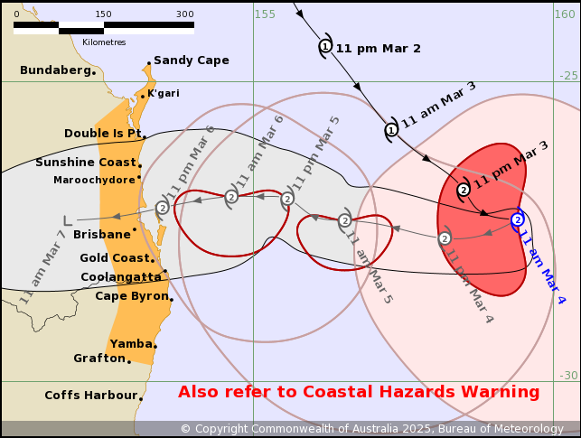
Details of Tropical Cyclone Alfred 22U at 10:00 am AEST [11:00 am
AEDT]:
Intensity: Category 2, sustained winds near the centre of 95
kilometres per hour with wind gusts to 130 kilometres per
hour.
Location: within 20 kilometres of 27.3 degrees South 159.4 degrees
East, estimated to be 630 kilometres east of Brisbane and 630
kilometres east of Maroochydore.
Movement: east southeast at 13 kilometres per hour.
Tropical Cyclone Alfred is expected to become slow moving and turn
west towards the Queensland coast later today.
Alfred's intensity may fluctuate between category 1 and 2 later
today and tomorrow, but it is forecast to cross the southeast
Queensland coast at category 2 strength late on Thursday or early
Friday.
Hazards:
ABNORMALLY HIGH TIDES which may cause MINOR FLOODING at the coast
between Sandy Cape and Yamba are expected to continue until at
least Friday. DAMAGING SURF leading to significant beach erosion
also remains likely for the open beaches between Sandy Cape and
Yamba. Refer to separate Coastal Hazard and Hazardous Surf Warning
current for southeast Queensland and northeastern New South Wales
coasts for more details.
Gales with DAMAGING WIND GUSTS to 120 kilometres per hour are
expected to develop along the southeast Queensland and northeastern
New South Wales coastal fringes and island communities between
Tewantin and Grafton on Wednesday. Gales may extend further north
from Tewantin to Sandy Cape late on Wednesday or early
Thursday.
Heavy rainfall is forecast for southeast Queensland and
northeastern New South Wales from Wednesday. HEAVY to locally
INTENSE RAINFALL which may lead to DANGEROUS AND LIFE-THREATENING
FLASH FLOODING may occur near and south of the cyclone centre as
Alfred approaches the coast late on Thursday or early Friday. Refer
to separate Flood Watch current for southeast Queensland and
northeastern New South Wales coasts for more details.
Refer to associated warnings for Queensland and New South Wales at
http://www.bom.gov.au/australia/warnings.
Recommended Action:
People between Sandy Cape in Queensland and Grafton in New South
Wales should consider what action they will need to take if the
cyclone threat increases.
- Information is available from your local government
- For cyclone preparedness and safety advice, visit the Get Ready
Queensland website (www.getready.qld.gov.au)
- For emergency assistance call the Queensland or New South Wales
State Emergency Service (SES) on 132 500 (for assistance with storm
damage, rising flood water, fallen trees on buildings or roof
damage).
Next Advice:
The next advice will be issued by 5:00 pm AEST Tuesday 04 March
[6:00 pm AEDT].
This warning is also available through TV and Radio Broadcasts;
the Bureau's website at www.bom.gov.au or call 1300 659 210. The
Bureau and the State Emergency Service would appreciate this
warning being broadcast regularly.
Current
Tropical Cyclones
04/Mar/2025 01:03 AM

