
Source: Bureau of Meteorology
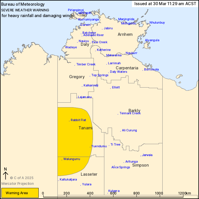
For people in Tanami and parts of Lasseter districts.
Issued at 11:29 am Sunday, 30 March 2025.
Heavy rainfall and possible damaging wind gusts developing Monday
across parts of the southwest associated with ex-Tropical Cyclone
Dianne.
Weather Situation: Ex-Tropical Cyclone Dianne in WA continues to
move to the south-southeast to impact parts of the Tanami and
Lasseter districts during Monday.
HEAVY RAINFALL which may lead to FLASH FLOODING is forecast to
develop during Monday in parts of the Tanami and Lasseter districts
as ex-Tropical Cyclone Dianne gradually moves towards the
southeast.
Six-hourly rainfall totals of 40 to 70 mm are possible, with
isolated totals up to 110 mm. 24-hourly totals of 70 to 110 mm are
possible, with isolated daily falls up to 150 mm.
Heavy rainfall is expected to ease later on Monday.
DAMAGING WIND GUSTS up to 90 km/h are possible, particularly in
association with thunderstorms.
Locations which may be affected include Yuendumu, Walungurru and
Rabbit Flat.
The Northern Territory Emergency Service advises that people
should:
* secure loose outside objects and seek shelter when conditions
deteriorate
* pull over if it is raining heavily and you cannot see, park with
your hazard lights on until the rain clears
* avoid driving into water of unknown depth and current
* create your own sandbags if there is flooding, by using pillow
cases or shopping bags filled with sand and place them around
doorways to protect your home
* stay away from flooded drains, rivers, streams and
waterways
* ensure pets and animals are safe
* be prepared in case of power outages, have an emergency kit with
a radio, torch, spare batteries and first aid kit
* for emergency help in floods, storms and cyclones, contact the
NTES on 132 500. For more safety tips visit
www.securent.nt.gov.au
30/Mar/2025 02:10 AM

