
Source: Bureau of Meteorology
Issued at 10:37 am EST on Saturday 29 March 2025
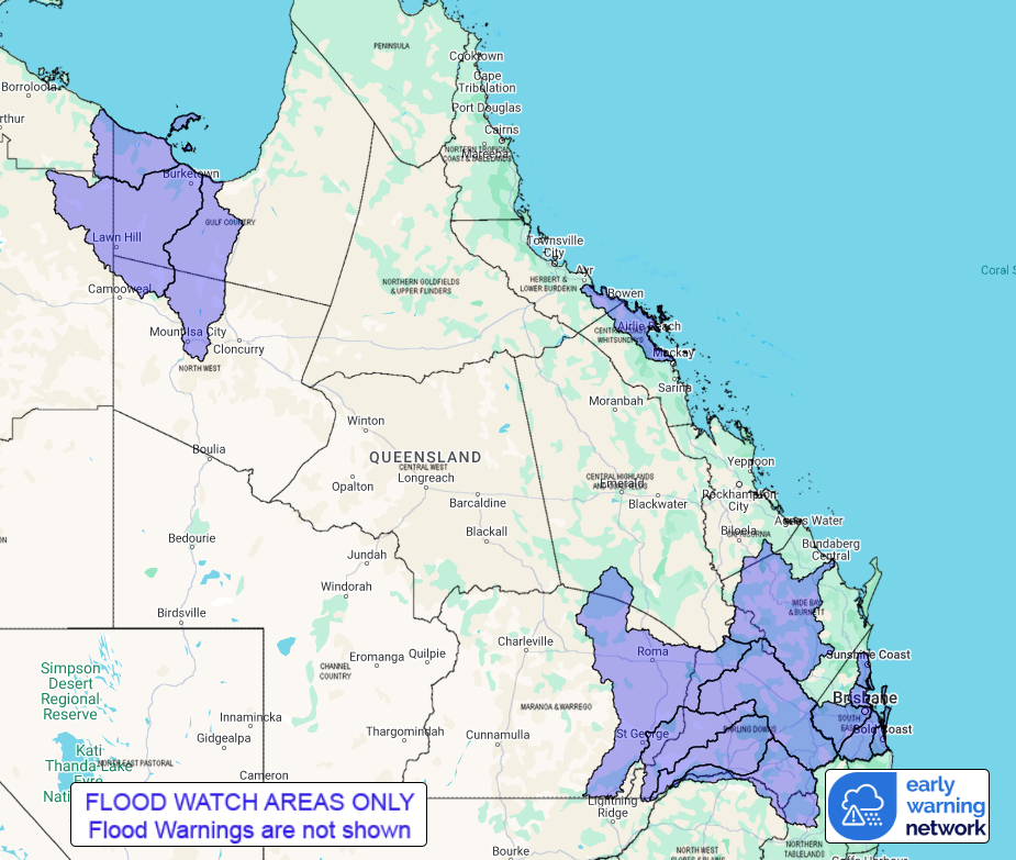
Flood Watch Number: 8
ISOLATED MAJOR FLOODING POSSIBLE IN INLAND AREAS OVER THE NEXT FEW
DAYS
MINOR TO MODERATE FLOODING POSSIBLE ACROSS SOUTHEASTERN AND GULF
CATCHMENTS
Showers, rain, and thunderstorms are forecast across much of
northern, central and southeast Queensland today as deep moisture
is drawn into an inland trough. Isolated heavy rainfall is possible
in southeastern, central, and northern Queensland in heavy showers
or severe thunderstorms today. Very isolated intense rainfall is
possible in the southeast.
Rainfall will ease in southern Queensland overnight on Saturday as
the trough moves off the southeast coast. Moderate rainfall is
possible over northern and central Queensland for the next few days
as a weak trough lingers but heavy rainfall is unlikely.
Catchments within the Flood Watch area are wet. Minor to major
flood warnings are current for numerous catchments across
Queensland adjacent to the Flood Watch area.
Localised river level rises, and flash flooding are likely within
the areas of heaviest rainfall. Localised flooding, isolation of
communities and disruption to transport routes are possible within
the Flood Watch area over the next few days.
A Severe Thunderstorm Warning for heavy rainfall is current for
parts of Wide Bay and Burnett and Southeast Coast Forecast
Districts.
Catchments likely to be affected include:
Settlement Creek
Nicholson River
Leichhardt River
Don and Proserpine Rivers
Burnett River
Sunshine Coast Rivers and Creeks
Pine and Caboolture Rivers
Lower Brisbane River(including Lockyer and Laidley Creeks and
creeks in Brisbane, but excluding the lower Brisbane River
itself)
Logan and Albert Rivers
Gold Coast Rivers and Creeks
Condamine Rivers
Macintyre River
Weir River
Moonie River
Balonne River
The Big Warrambool River
Flood warnings are current for the following catchments: Bulloo,
Diamantina, Thomson, Barcoo, Cooper, Eyre Creek, Georgina,
Flinders, Cloncurry, Warrego, Paroo, Maranoa, Herbert, Ross, Bohle,
Haughton, Burdekin, Pioneer, Mary, Norman, Gilbert,
Burrum-Cherwell, Upper Brisbane, Bremer-Warrill, Wallum and
Mungallala, Connors-Isaac.
See www.bom.gov.au/qld/warnings to view the current flood, weather
and cyclone products for Queensland.
For more information on the Flood Watch Service:
http://www.bom.gov.au/water/floods/floodWarningServices.html
Flood Safety Advice:
This Flood Watch means that people living or working along rivers
and creeks should monitor the latest weather forecasts and
warnings.
Remember: If it's flooded, forget it.
For flood emergency assistance contact the SES on 132 500.
For life threatening emergencies, call Triple Zero (000)
immediately.
Current emergency information is available at
www.qld.gov.au/alerts.
This advice is also available by dialling 1300 659 219 at a low
call cost of 27.5 cents, more from mobile, public and satellite
phones.
Warning, rainfall and river information are available at
www.bom.gov.au/qld/flood/
Rainfall and River
Conditions Map
29/Mar/2025 12:54 AM

