
Source: Bureau of Meteorology
For people in parts of North Tropical Coast and Tablelands,
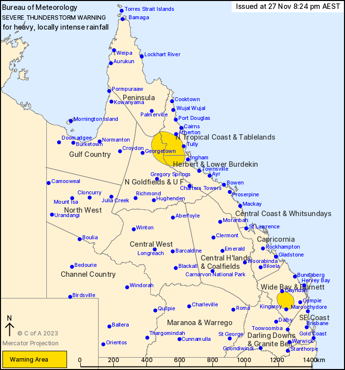
Northern Goldfields and Upper Flinders, Herbert and Lower Burdekin,
Wide Bay and Burnett and Peninsula Forecast Districts.
Issued at 8:24 pm Monday, 27 November 2023.
Very dangerous storms around Proston while severe storms observed
over SW North Tropical Coast.
Weather Situation: Multiple troughs are combining with a moist and
unstable airmass to produce severe thunderstorms across a large
portion of the state.
Severe thunderstorms are likely to produce heavy, locally intense
rainfall that may lead to dangerous and life-threatening flash
flooding over the next several hours in parts of the Wide Bay and
Burnett district. Locations which may be affected include
Cherbourg, Wondai and Murgon.
Severe thunderstorms are likely to produce heavy rainfall that may
lead to flash flooding over the next several hours in parts of the
North Tropical Coast and Tablelands, Northern Goldfields and Upper
Flinders, Herbert and Lower Burdekin and Peninsula districts.
Locations which may be affected include Millaa Millaa, Ravenshoe,
Abergowrie and Mount Garnet.
Severe thunderstorms are no longer occurring in the Gulf Country,
North West, Central West, Darling Downs and Granite Belt and
Southeast Coast districts and the warning for these districts is
CANCELLED.
Significant rainfall observations:
Gunnawarra (SW North Tropical Coast) recorded 55 mm in 1
hour
Cherbourg recorded 71.5 mm in 60 minutes to 7 pm
Amiens Knob (W of Stanthorpe) recorded 35 mm in 30 minutes to 7:00
pm
Bellbird Park (near Redbank Plains in SE Coast) recorded 60 mm in
1 hour to 7:27 pm
Gregor Creek (near Kilcoy/Somerset Dam) recorded 80 mm in 1 hour
to 5:00 pm
Mt Stanley (near Kilcoy/Somerset Dam) recorded 55 mm in 1 hour to
4:13 pm
Queensland Fire and Emergency Services advises that people
should:
* Never drive, walk or ride through flood waters. If it's flooded,
forget it.
* Seek shelter, preferably indoors and never under trees.
* Avoid using the telephone during a thunderstorm.
* Beware of fallen trees and powerlines.
* For emergency assistance contact the SES on 132 500.
27/Nov/2023 10:34 AM

