
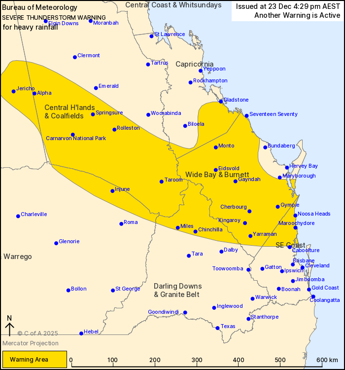
Source: Bureau of Meteorology
For people in Wide Bay and Burnett and parts of Central Highlands
and Coalfields, Central West, Capricornia, Maranoa and Warrego,
Darling Downs and Granite Belt and Southeast Coast Forecast
Districts.
Issued at 4:29 pm Tuesday, 23 December 2025.
Severe thunderstorms with isolated heavy falls over the southeast
this afternoon and evening.
Weather Situation: Slow-moving thunderstorms are continuing within
a very moist and unstable airmass along a surface trough in the
southeast.
Severe thunderstorms are likely to produce heavy rainfall that may
lead to flash flooding in the warning area over the next several
hours. Locations which may be affected include Maroochydore,
Gympie, Kingaroy, Noosa Heads, Cherbourg and Taroom.
51mm was recorded at Mt Tabor (Carnarvon National Park) in the 1
hour to 3:06 pm.
Emergency services advise people to:
* Park your car undercover away from trees.
* Close doors and windows.
* Keep asthma medications close by. Storms and wind can trigger
asthma attacks.
* Charge mobile phones and power banks in case the power goes
out.
* Put your pets somewhere safe and make sure they can be
identified in case they get lost.
* Do not drive now unless you have to because conditions are
dangerous.
* Tell friends, family and neighbours in the area.
* Go inside a strong building now. Stay inside until the storm has
passed.
23/Dec/2025 06:39 AM

