
Source: Bureau of Meteorology
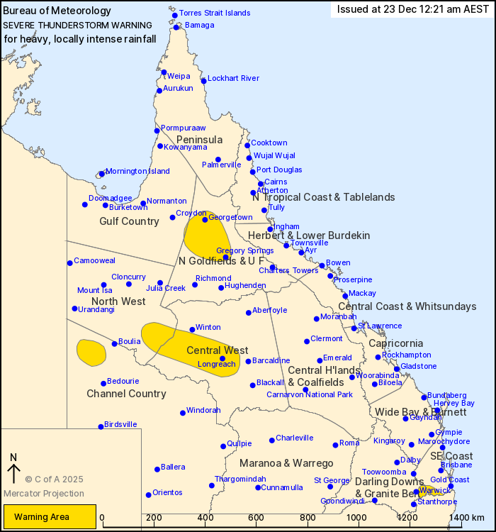
For people in parts of Northern Goldfields and Upper Flinders,
North West, Central West, Channel Country, Southeast Coast and Gulf
Country Forecast Districts.
Issued at 2:00 am Tuesday, 23 December 2025.
Severe thunderstorms continuing over the interior this
morning.
Weather Situation: A cold front combines with humid and unstable
atmospheric conditions to promote severe thunderstorms.
VERY DANGEROUS THUNDERSTORMS are likely to produce heavy, locally
intense rainfall that may lead to dangerous and life-threatening
flash flooding in the warning area over the next several hours.
Locations which may be affected include the area east of
Warwick.
Severe thunderstorms are likely to produce heavy rainfall that may
lead to flash flooding in the warning area over the next several
hours. Locations which may be affected include Georgetown, Gregory
Springs, Boonah, Stonehenge, Forsayth, Einasleigh, Glenormiston,
Lyndhurst Station and Brighton Downs.
Severe thunderstorms are no longer occurring in the Darling Downs
and Granite Belt district and the warning for this district is
CANCELLED.
58 MM WAS RECORDED AT MARION DOWNS IN THE 30 MINUTES TO 10:13
PM.
44.0 mm was recorded at Yangan (Swan Creek) in the 30 minutes to
12:00 am.
75.6 mm was recorded at Georgetown Airport in the 1 hour to 10:33
pm.
73 mm was recorded at Roxborough Downs in the 3 hours to 10:00
pm.
Emergency services advise people to:
* If you have children make sure they are with you or an adult you
trust.
* Park your car undercover away from trees.
* Close doors and windows.
* Keep asthma medications close by. Storms and wind can trigger
asthma attacks.
* Charge mobile phones and power banks in case the power goes
out.
* Put your pets somewhere safe and make sure they can be
identified in case they get lost.
* Do not drive now unless you have to because conditions are
dangerous.
* Tell friends, family and neighbours in the area.
* Go inside a strong building now. Stay inside until the storm has
passed.
22/Dec/2025 04:12 PM

