
Source: Bureau of Meteorology
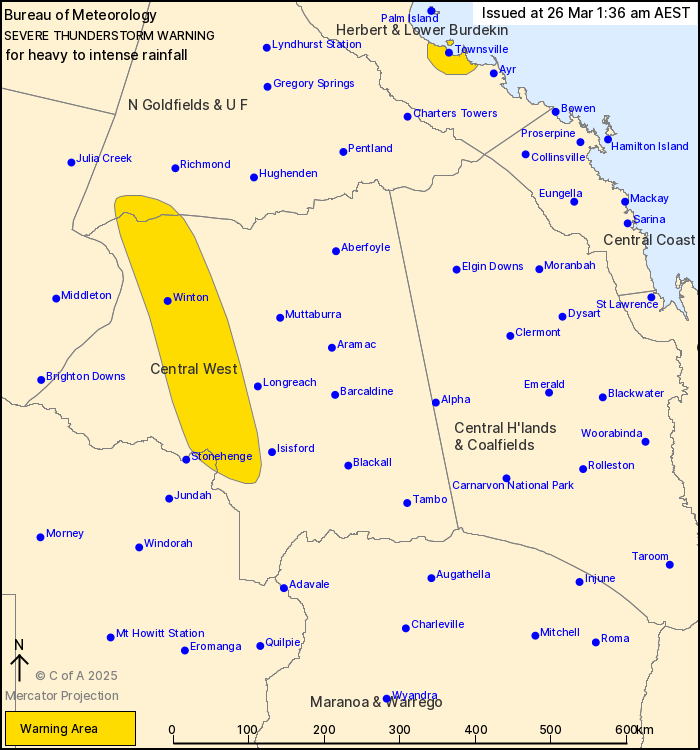
For people in parts of Northern Goldfields and Upper Flinders,
Herbert and Lower Burdekin, Central West and Channel Country
Forecast Districts.
Issued at 1:36 am Wednesday, 26 March 2025.
INTENSE RAINFALL WITH THUNDERSTORMS IN CENTRAL QUEENSLAND AND
HEAVY RAINFALL AROUND TOWNSVILLE
Weather Situation: A deep surface trough with an embedded low
pressure system situated over western Queensland is drawing deep
tropical moisture across much of the state. This is producing
showers and thunderstorms with heavy to intense rainfall.
VERY DANGEROUS THUNDERSTORMS are likely to produce intense
rainfall that may lead to dangerous and life-threatening flash
flooding over the next several hours in parts of the Northern
Goldfields and Upper Flinders, Central West and Channel Country
districts. Locations which may be affected include Winton, Evesham
Station and Corfield.
Severe thunderstorms are likely to produce heavy rainfall that may
lead to flash flooding over the next several hours in parts of the
Herbert and Lower Burdekin district. Locations which may be
affected include Townsville and Giru.
Bogewong (Central West) recorded 100mm in 3 hours to 12:30am
AEST.
The Pinnacles (Townsville) recorded 114mm in 3 hours to 1:20am
AEST.
Emergency services advise people to:
* If you have children make sure they are with you or an adult you
trust.
* Park your car undercover away from trees.
* Close doors and windows.
* Keep asthma medications close by. Storms and wind can trigger
asthma attacks.
* Charge mobile phones and power banks in case the power goes
out.
* Put your pets somewhere safe and make sure they can be
identified in case they get lost.
* Do not drive now unless you have to because conditions are
dangerous.
* Tell friends, family and neighbours in the area.
* Go inside a strong building now. Stay inside until the storm has
passed.
25/Mar/2025 03:42 PM

