
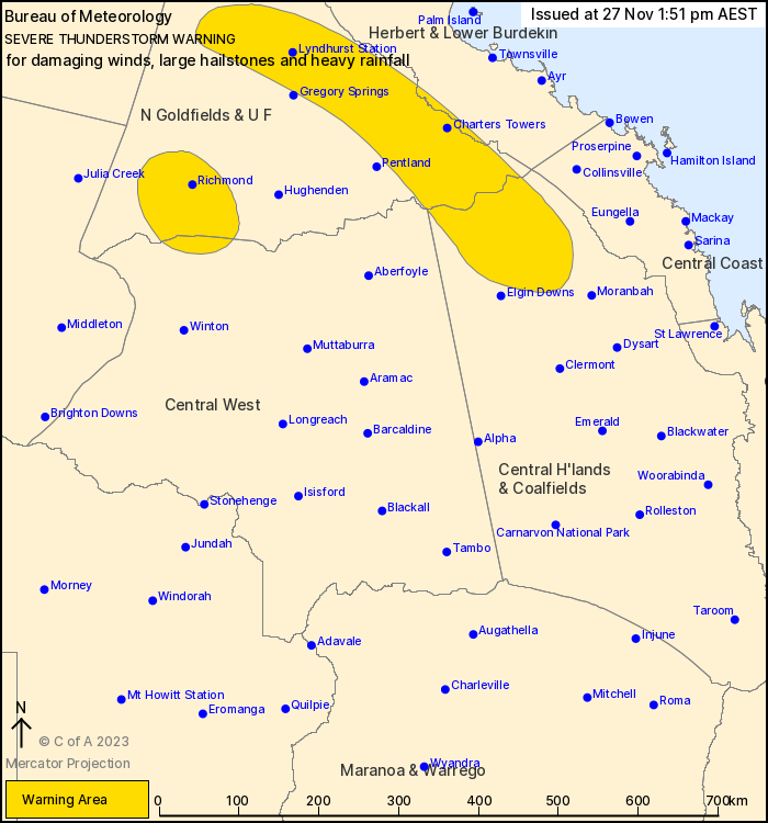
Source: Bureau of Meteorology
For people in parts of Northern Goldfields and Upper Flinders,
Herbert and Lower Burdekin, Central Highlands and Coalfields and
Central West Forecast Districts.
Issued at 1:51 pm Monday, 27 November 2023.
Severe storm detected west of Richmond, with other severe activity
developing over northeastern interior.
Weather Situation: Multiple troughs will combine with a moist and
unstable airmass to produce severe thunderstorms across a large
portion of the state.
Severe thunderstorms are likely to produce damaging winds and
large hailstones over the next several hours in parts of the
Northern Goldfields and Upper Flinders and Central West districts.
Locations which may be affected include Richmond.
Severe thunderstorms are likely to produce heavy rainfall that may
lead to flash flooding over the next several hours in parts of the
Northern Goldfields and Upper Flinders, Herbert and Lower Burdekin,
Central Highlands and Coalfields and Central West districts.
Locations which may be affected include Charters Towers, Lyndhurst
Station and Natal Downs.
Queensland Fire and Emergency Services advises that people
should:
* Move your car under cover or away from trees.
* Secure loose outdoor items.
* Never drive, walk or ride through flood waters. If it's flooded,
forget it.
* Seek shelter, preferably indoors and never under trees.
* Avoid using the telephone during a thunderstorm.
* Beware of fallen trees and powerlines.
* For emergency assistance contact the SES on 132 500.
27/Nov/2023 03:57 AM


