
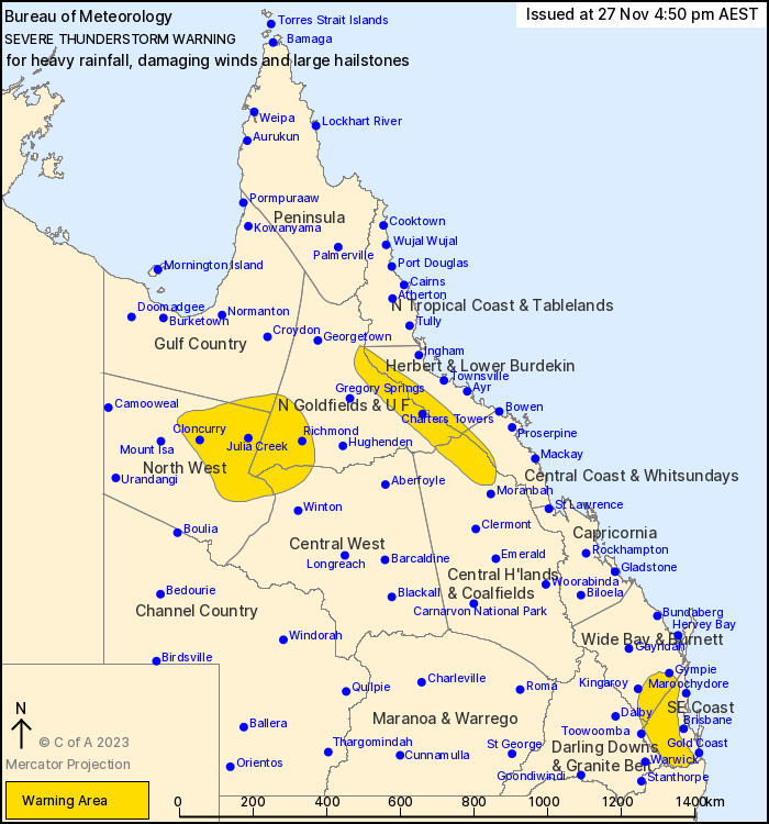
Source: Bureau of Meteorology
For people in Southeast Coast and parts of Gulf Country, Northern
Goldfields and Upper Flinders, Herbert and Lower Burdekin, North
West, Central Coast and Whitsundays, Central Highlands and
Coalfields, Central West, Wide Bay and Burnett and Darling Downs
and Granite Belt Forecast Districts.
Issued at 4:50 pm Monday, 27 November 2023.
Severe storms occurring across various parts of the state, now
including the northwest.
Weather Situation: Multiple troughs are combining with a moist and
unstable airmass to produce severe thunderstorms across a large
portion of the state.
Severe thunderstorms are likely to produce heavy rainfall that may
lead to flash flooding over the next several hours in the Southeast
Coast and parts of the Northern Goldfields and Upper Flinders,
Herbert and Lower Burdekin, Central Coast and Whitsundays, Central
Highlands and Coalfields, Wide Bay and Burnett and Darling Downs
and Granite Belt districts. Locations which may be affected include
Charters Towers, Ipswich, Jimboomba, Laidley, Lowood and
Nanango.
Severe thunderstorms are likely to produce damaging winds, large
hailstones and heavy rainfall that may lead to flash flooding over
the next several hours in parts of the Gulf Country, Northern
Goldfields and Upper Flinders, North West and Central West
districts. Locations which may be affected include Cloncurry,
Richmond, Julia Creek, Mckinlay and Cloney's Creek.
Significant rainfall observations:
Stewarts Bridge (S of Monto) recorded 56mm within an hour to 3:38
pm.
Queensland Fire and Emergency Services advises that people
should:
* Move your car under cover or away from trees.
* Secure loose outdoor items.
* Never drive, walk or ride through flood waters. If it's flooded,
forget it.
* Seek shelter, preferably indoors and never under trees.
* Avoid using the telephone during a thunderstorm.
* Beware of fallen trees and powerlines.
* For emergency assistance contact the SES on 132 500.
27/Nov/2023 06:56 AM


