
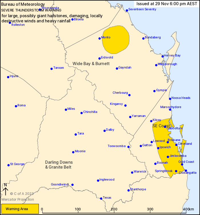
Source: Bureau of Meteorology
For people in parts of Wide Bay and Burnett and Southeast Coast
Forecast Districts.
Issued at 6:00 pm Wednesday, 29 November 2023.
VERY DANGEROUS STORMS possible in the southeast.
Weather Situation: A surface trough in combination with an upper
disturbance has resulted in severe thunderstorms developing across
parts of the southeast inland this afternoon.
Severe thunderstorms are likely to produce large hailstones,
damaging winds and heavy rainfall that may lead to flash flooding
over the next several hours in parts of the Wide Bay and Burnett
district.
Severe thunderstorms are likely to produce damaging, locally
destructive winds, large, possibly giant hailstones and heavy
rainfall that may lead to flash flooding over the next several
hours in parts of the Southeast Coast district. Locations which may
be affected include Gold Coast, Brisbane, Caboolture, Coolangatta,
Ipswich and Redcliffe.
Queensland Fire and Emergency Services advises that people
should:
* Move your car under cover or away from trees.
* Secure loose outdoor items.
* Never drive, walk or ride through flood waters. If it's flooded,
forget it.
* Seek shelter, preferably indoors and never under trees.
* Avoid using the telephone during a thunderstorm.
* Beware of fallen trees and powerlines.
* For emergency assistance contact the SES on 132 500.
29/Nov/2023 08:32 AM


