
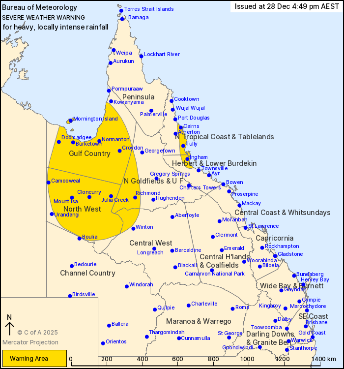
Source: Bureau of Meteorology
For people in Gulf Country, North West and parts of North Tropical
Coast and Tablelands, Northern Goldfields and Upper Flinders,
Herbert and Lower Burdekin and Central West Forecast
Districts.
Issued at 4:49 pm Sunday, 28 December 2025.
HEAVY, LOCALLY INTENSE RAINFALL CONTINUES TO DEVELOP FOR
NORTHWESTERN QUEENSLAND AND THE NORTHEAST TROPICAL COAST.
Weather Situation: A monsoon trough extends across the northwest
and contains an embedded low pressure system located south of
Burketown. This low is expected to continue strengthening as it
gradually tracks south to southeast. Over the Northeast Tropical
Coast, enhanced onshore winds are forecast to strengthen and
converge from Sunday evening. Together, these systems are likely to
generate widespread heavy rainfall across parts of northern
Queensland.
For NORTHWEST QUEENSLAND: HEAVY RAINFALL which may lead to FLASH
FLOODING is forecast to continue developing for parts of Gulf
Country, Northern Goldfields and Upper Flinders, North West and
Central West Forecast Districts during Sunday, persisting through
Monday. Six-hourly rainfall totals between 75 to 120 mm are likely.
Locally INTENSE RAINFALL which may lead to DANGEROUS AND
LIFE-THREATENING FLASH FLOODING is possible during this period with
six-hourly rainfall totals up to 180 mm.
Areas of heavy rainfall about northwest Queensland are forecast to
persist into early next week, with locations and rainfall totals
subject to the position and strength of the low pressure system.
These conditions also present a risk to cattle and other
livestock.
For NORTHEAST TROPICAL COAST: HEAVY RAINFALL which may lead to
FLASH FLOODING is forecast to develop for areas between Cairns and
north of Townsville from this evening, persisting through Monday.
Six-hourly rainfall totals between 120 to 200 mm are likely.
Locally INTENSE RAINFALL which may lead to DANGEROUS AND
LIFE-THREATENING FLASH FLOODING is possible during this period with
six-hourly rainfall totals up to 260 mm.
A separate Severe Thunderstorm Warning will be issued if very
dangerous thunderstorms with intense rainfall are detected.
Flood Watches and Flood Warnings are current for Northern
Queensland. Please refer to
https://www.bom.gov.au/weather-and-climate/warnings-and-alerts for
more information.
Locations which may be affected include Mount Isa, Cloncurry,
Burketown, Mornington Island, Normanton, Cairns, Innisfail, Tully,
Doomadgee, Richmond, Julia Creek, Camooweal, Ingham and
Croydon.
Emergency services advise people to:
* If you have children make sure they are with you or an adult you
trust.
* Park your car undercover away from trees.
* Close doors and windows.
* Keep asthma medications close by. Storms and wind can trigger
asthma attacks.
* Charge mobile phones and power banks in case the power goes
out.
* Put your pets somewhere safe and make sure they can be
identified in case they get lost.
* Do not drive now unless you have to because conditions are
dangerous.
* Tell friends, family and neighbours in the area.
* Go inside a strong building now. Stay inside until the storm has
passed.
28/Dec/2025 07:14 AM

