
Source: Bureau of Meteorology
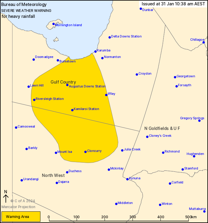
For people in parts of Gulf Country and North West Forecast
Districts.
Issued at 10:38 am Wednesday, 31 January 2024.
Heavy rainfall continues about Ex-Tropical Cyclone Kirrily,
extending into the Gulf Country today.
Weather situation: Ex-Tropical Cyclone Kirrily is currently
located about 50 km to the north of Mount Isa. The system is
expected to continue tracking steadily to the north-northwest today
and into Thursday morning. It is then expected to stall just south
of the Gulf Country coast on Thursday afternoon.
HEAVY RAINFALL which may lead to FLASH FLOODING is likely in the
North West district and southern parts of the Gulf Country today,
before extending towards the Gulf Country coast overnight. 6-hourly
rainfall totals between 60 and 140 mm are possible. 24-hourly
rainfall totals between 100 and 200 mm are also possible.
A Flood Watch and several Flood Warnings are also current for the
Central West, Channel Country and Gulf of Carpentaria catchments.
See http://www.bom.gov.au/qld/warnings/ for more information.
Locations which may be affected include Cloncurry, Kamilaroi
Station, Augustus Downs Station, Donors Hill Station, Gregory Downs
Station and Iffley.
Severe weather is no longer occurring in the Northern Goldfields
and Upper Flinders and Central West districts and the warning for
these districts is CANCELLED.
147 mm recorded at Trepell Airport in the 24 hours to 9am
Emergency services advise people to:
* Park your car undercover away from trees.
* Close doors and windows.
* Keep asthma medications close by. Storms and wind can trigger
asthma attacks.
* Charge mobile phones and power banks in case the power goes
out.
* Put your pets somewhere safe and make sure they can be
identified in case they get lost.
* Do not drive now unless you have to because conditions are
dangerous.
* Tell friends, family and neighbours in the area.
* Go inside a strong building now. Stay inside until the storm has
passed.
31/Jan/2024 12:45 AM

