
Source: Bureau of Meteorology
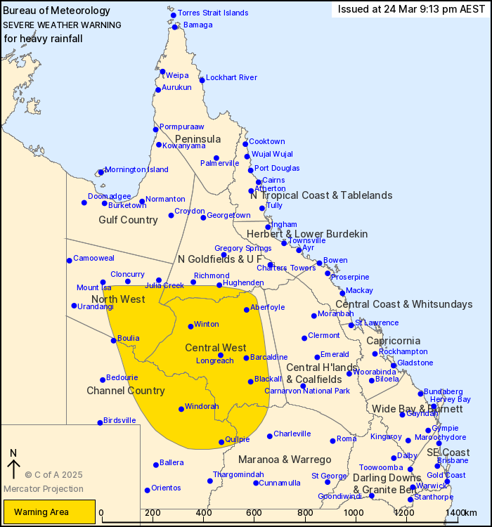
For people in Central West and parts of Northern Goldfields and
Upper Flinders, North West, Channel Country and Maranoa and Warrego
Forecast Districts.
Issued at 9:13 pm Monday, 24 March 2025.
Heavy rainfall continues over inland parts of the state overnight
and throughout Tuesday.
Weather Situation: A deep surface trough is situated over the west
of state and will combine with a very moist tropical airmass to
produce areas of heavy rainfall. Scattered rain, heavy showers and
isolated thunderstorms will continue over western and central parts
of the state overnight and throughout Tuesday, as a low pressure
system develops within the trough.
HEAVY RAINFALL which may lead to FLASH FLOODING is likely through
the warning area overnight and will continue during Tuesday.
Six-hourly rainfall totals between 40 and 60 mm are likely, with
isolated falls of up to 100 mm possible. 24-hourly rainfall totals
of between 70 to 100 mm are likely, with isolated totals of up to
200 mm possible.
Conditions are likely to ease during Wednesday.
Flood Watches and Warnings have been issued for multiple
catchments in the west and centre of the state. See
http://www.bom.gov.au/qld/warnings/ for more information.
Locations which may be affected include Longreach, Winton,
Quilpie, Windorah, Isisford and Barcaldine.
111 MM WAS RECORDED AT MALBOONA IN THE THREE HOURS TO 7:02
PM.
83 mm was recorded at Hamilton River Station in the 6 hours to
10.35 am.
Emergency services advise people to:
* Park your car undercover away from trees.
* Close doors and windows.
* Keep asthma medications close by. Storms and wind can trigger
asthma attacks.
* Charge mobile phones and power banks in case the power goes
out.
* Put your pets somewhere safe and make sure they can be
identified in case they get lost.
* Do not drive now unless you have to because conditions are
dangerous.
* Tell friends, family and neighbours in the area.
* Go inside a strong building now. Stay inside until the storm has
passed.
24/Mar/2025 11:25 AM

