
Source: Bureau of Meteorology
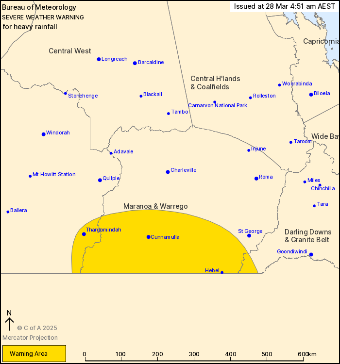
For people in parts of Channel Country, Maranoa and Warrego and
Darling Downs and Granite Belt Forecast Districts.
Issued at 4:51 am Friday, 28 March 2025.
Moderate to heavy rainfall risk continues about the southern
interior today.
Weather Situation: A deep surface trough has combined with a very
moist tropical airmass and upper feature to generate widespread
heavy rainfall over the western and southern interior over the past
few days. Moderate falls with isolated pockets of heavy rainfall is
expected to persist about the southern interior today, gradually
easing during the afternoon.
Moderate to HEAVY RAINFALL which may lead to FLASH FLOODING is
possible throughout the warning area today, gradually easing during
the afternoon. Six-hourly rainfall totals between 30 and 50 mm are
likely, with isolated falls of up to 80 mm possible. 24-hourly
rainfall totals of between 50 to 100 mm are likely, with isolated
totals of up to 130 mm possible.
Flood Watches and Warnings have been issued for multiple
catchments in the west and centre of the state. See
http://www.bom.gov.au/qld/warnings/ for more information.
Locations which may be affected include Thargomindah, Cunnamulla,
Hebel, Hungerford, Bollon and Barringun.
Significant 24-hour rainfall totals to 9:00 am Thursday
include:
228 mm at Wahroonga.
177 mm at Dilladah.
146 mm at Mahrigong.
139 mm at Bogewong.
Emergency services advise people to:
* Park your car undercover away from trees.
* Close doors and windows.
* Keep asthma medications close by. Storms and wind can trigger
asthma attacks.
* Charge mobile phones and power banks in case the power goes
out.
* Put your pets somewhere safe and make sure they can be
identified in case they get lost.
* Do not drive now unless you have to because conditions are
dangerous.
* Tell friends, family and neighbours in the area.
* Go inside a strong building now. Stay inside until the storm has
passed.
27/Mar/2025 08:25 PM

