
Source: Bureau of Meteorology
Issued at 4:51 pm EST on Saturday 10 January 2026
Headline:
Tropical Cyclone Koji has developed, and is moving towards the
northeast Queensland coast.
Areas Affected:
Warning zone: Innisfail to Mackay, including Townsville, Palm
Island, Bowen, Proserpine and Whitsunday Islands.
Watch zone: None.
Cancelled zone: None.
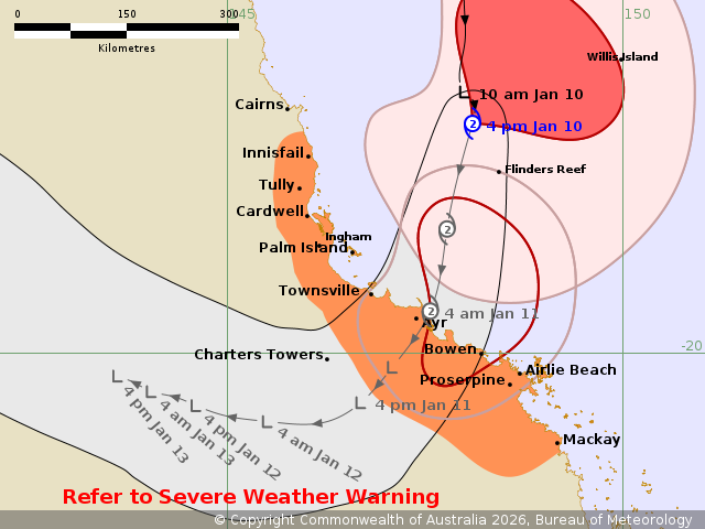
Details of Tropical Cyclone Koji 12U at 4:00 pm AEST:
Intensity: Category 2, sustained winds near the centre of 95
kilometres per hour with wind gusts to 130 kilometres per
hour.
Location: within 45 kilometres of 17.1 degrees South 148.1 degrees
East, estimated to be 275 kilometres north northeast of Townsville
and 225 kilometres east northeast of Innisfail.
Movement: south at 13 kilometres per hour.
Tropical Cyclone Koji (12U) is located in the Coral Sea offshore
of the North Tropical Coast and is moving south towards the
Queensland coast.
Koji, a category 2 system, is forecast to continue on a similar
south track until crossing the coast. The coastal crossing is
forecast for early Sunday morning between Townsville and Bowen.
After crossing, Koji will weaken and then track generally
westwards.
Hazards:
DESTRUCTIVE WIND GUSTS to 130 km/h are possible from this evening
and into early Sunday morning about exposed coastal locations from
south of Townsville to Proserpine.
GALES with DAMAGING WIND GUSTS to 100 km/h are expected to develop
over coastal areas between Cardwell and Airlie Beach, this
afternoon or evening. GALES may extend north, to areas between
Innisfail and Cardwell this evening if Koji takes a track further
west. GALES may extend south, to areas between Proserpine and
Mackay, and adjacent inland areas overnight and early Sunday
morning.
Gales are expected to ease as the system crosses the coast and
moves inland during Sunday.
HEAVY RAINFALL, which may lead to FLASH FLOODING, is forecast to
develop from Ingham to Proserpine tonight. Locally INTENSE
RAINFALL, which may lead to DANGEROUS AND LIFE-THREATENING FLASH
FLOODING, is possible between Townsville and Proserpine later
tonight, extending south to Mackay on Sunday.
Tides are likely to be higher than normal between Cardwell and
Mackay over the weekend but should not exceed the highest tide of
the year.
A Severe Weather Warning is also current for heavy to locally
intense rainfall and damaging winds about the northeast and central
Queensland coasts. Flood Watches and Warnings are also
current.
Recommended Action:
People between Ayr to Proserpine, including Bowen and Airlie Beach
should complete preparations now and be prepared to shelter in a
safe place.
- Boats and outside property should be secured before nightfall if
safe to do so.
People between Innisfail and Mackay, including Innisfail,
Townsville, Palm Island should take precautions and listen to the
next advice at 8 pm.
- Stay informed by checking your local government s Disaster
Dashboards for the latest updates.
- For cyclone preparedness and safety advice, visit the Get Ready
Queensland website www.getready.qld.gov.au
IF YOUR LIFE IS IN DANGER PHONE TRIPLE ZERO (000) IMMEDIATELY. For
non-life threatening emergency assistance contact State Emergency
Services (SES) online via the SES Assistance QLD App (Apple,
Android), online 132500.qld.gov.au, or call 132 500 from anywhere
in Queensland.
Current
Tropical Cyclones
10/Jan/2026 07:01 AM


