
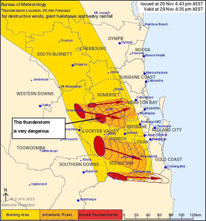
Source: Bureau of Meteorology
For people in Scenic Rim and parts of Ipswich, Logan, Somerset,
Toowoomba, Lockyer Valley, Gold Coast, Brisbane City, Moreton Bay
and Southern Downs Council Areas.
Issued at 4:43 pm Wednesday, 29 November 2023.
VERY DANGEROUS THUNDERSTORM SOUTH OF ESK WITH GIANT HAIL.
The Bureau of Meteorology warns that, at 4:35 pm, very dangerous
thunderstorms were detected on the weather radar near the area
southwest of Esk.
These thunderstorms are moving towards the east.
Very dangerous thunderstorms are forecast to affect Esk, the area
south of Esk and northern Lake Wivenhoe by 5:05 pm and the
D'Aguilar Ranges, Lake Samsonvale and Dayboro by 5:35 pm.
Other severe thunderstorms were detected on the weather radar near
Mount Barney, Haden, the area west of Toogoolawah and the area
northwest of Cunninghams Gap.
They are forecast to affect Boonah, the area northwest of Esk and
Crows Nest by 5:05 pm and Beaudesert, the area between Boonah and
Beaudesert and Lake Somerset by 5:35 pm.
Damaging, locally destructive winds, large, possibly giant
hailstones and heavy rainfall that may lead to flash flooding are
likely.
Queensland Fire and Emergency Services advises that people
should:
* Move your car under cover or away from trees.
* Secure loose outdoor items.
* Never drive, walk or ride through flood waters. If it's flooded,
forget it.
* Seek shelter, preferably indoors and never under trees.
* Avoid using the telephone during a thunderstorm.
* Beware of fallen trees and powerlines.
* For emergency assistance contact the SES on 132 500.
29/Nov/2023 06:55 AM


