
Source: Bureau of Meteorology
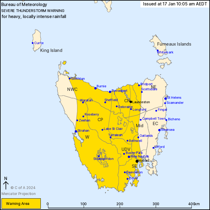
For people in Western, Upper Derwent Valley, South East, North
West Coast, Central North, Central Plateau and parts of North East
and Midlands Forecast Districts.
Issued at 10:05 am Wednesday, 17 January 2024.
VERY DANGEROUS THUNDERSTORMS WITH HEAVY, LOCALLY INTENSE RAINFALL
ACROSS NORTHERN-CENTRAL TASMANIA.
Weather Situation: A warm and very humid airmass ahead of a cold
front is generating severe thunderstorms with heavy rainfall
embedded within a broader rainband over western and northern parts
of Tasmania. Locally intense rainfall with a band of thunderstorms
about the Central Plateau north to George Town.
VERY DANGEROUS THUNDERSTORMS are likely to produce heavy, locally
intense rainfall that may lead to dangerous and life-threatening
flash flooding over the next several hours in parts of the North
West Coast, Central North, Central Plateau and Midlands districts.
Locations which may be affected include Deloraine and George
Town.
Severe thunderstorms are likely to produce heavy rainfall that may
lead to flash flooding over the next several hours in the Western,
Upper Derwent Valley, South East, North West Coast, Central North,
Central Plateau and parts of the North East and Midlands districts.
Locations which may be affected include Devonport, Burnie,
Launceston, Strahan, New Norfolk and Hobart.
Sheffield School Farm recorded 46.6 mm in 3 hours to 9:15
am.
Mount Read recorded 17.8 mm in 30 minutes to 7:30 am.
The State Emergency Service advises that people should:
* Avoid driving, walking or riding through flood waters.
* Seek shelter, preferably indoors and never under trees.
* Avoid using the telephone during a thunderstorm.
* Beware of fallen trees and powerlines.
* For emergency assistance contact the SES on 132500.
16/Jan/2024 11:13 PM

