
Source: Bureau of Meteorology
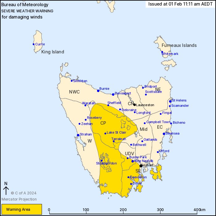
For people in South East, Central Plateau and parts of Western,
Upper Derwent Valley, North West Coast, Central North and Midlands
Forecast Districts.
Issued at 11:11 am Thursday, 1 February 2024.
Damaging wind gusts developing this afternoon and persisting into
Friday.
Weather Situation: A deep low in the Southern Ocean and a high
pressure system in the Great Australian Bight will increase the
pressure gradient over Tasmania today, resulting in damaging
westerly winds developing across the central west from this
afternoon before extending into the Tasman Peninsula overnight.
Winds are expected to ease below thresholds across the state during
Friday afternoon.
DAMAGING WIND GUSTS gusts of around 100 km/h are likely to develop
across the elevated areas of the southwest and central west of the
state this afternoon, extending to lower elevation areas southwest
of Hobart as well, before extending to the Tasman Peninsula later
this evening. Gusts in excess of 110 km/h are possible over the
higher peaks of the southwest and Western Tiers.
Winds are expected to ease below warning thresholds by Friday
afternoon.
Locations which may be affected include Strathgordon, New Norfolk,
Tarraleah, Geeveston, Dover and Huonville.
The State Emergency Service advises that people should:
* Supervise children closely.
* Check that family and neighbours are aware of warnings.
* Manage pets and livestock.
* Secure outdoor items including furniture and play
equipment.
* Be prepared in case of power outages and report any outages to
TasNetworks on 132 004.
* Beware of damaged trees and power lines and take care when
driving.
* Listen to the ABC radio or check www.ses.tas.gov.au for further
advice.
* For emergency assistance contact the SES on 132500.
01/Feb/2024 12:20 AM


