
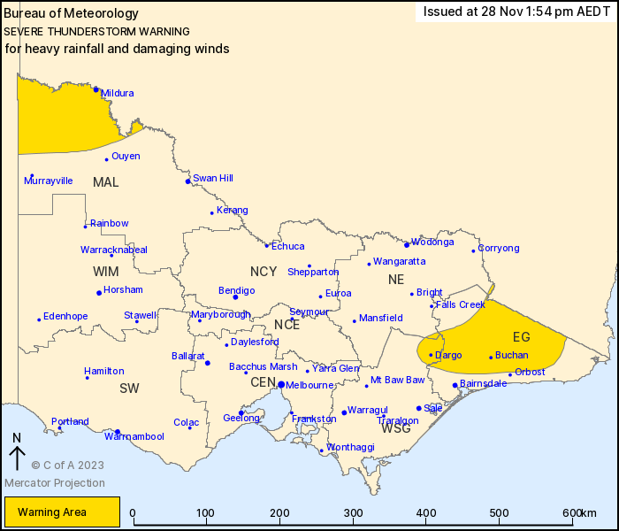
Source: Bureau of Meteorology
For people in parts of East Gippsland, Mallee, West and South
Gippsland and North East Forecast Districts.
Issued at 1:54 pm Tuesday, 28 November 2023.
Severe storms with heavy rainfall now developing from Dargo to the
Vic/NSW border.
Weather Situation: A moist and unstable airmass will link up with
low-level convergence to trigger a few severe thunderstorms over
this East Gippsland this afternoon. In addition, a front and an
upper low over SA will support severe thunderstorms across the
northwest.
Severe thunderstorms are likely to produce heavy rainfall that may
lead to flash flooding over the next several hours in parts of the
East Gippsland, West and South Gippsland and North East districts.
Locations which may be affected include Dargo, Buchan, Chandlers
Creek, Combienbar, Gelantipy and Bonang.
Severe thunderstorms are likely to produce damaging winds and
heavy rainfall that may lead to flash flooding over the next
several hours in parts of the Mallee district. Locations which may
be affected include Mildura and Robinvale.
The State Emergency Service advises that people should:
* If driving conditions are dangerous, safely pull over away from
trees, drains, low-lying areas and floodwater. Avoid travel if
possible.
* Stay safe by avoiding dangerous hazards, such as floodwater,
mud, debris, damaged roads and fallen trees.
* Be aware - heat, fire or recent storms may make trees unstable
and more likely to fall when it's windy or wet.
* Check that loose items, such as outdoor settings, umbrellas and
trampolines are safely secured. Move vehicles under cover or away
from trees.
* Stay indoors and away from windows.
* If outdoors, move to a safe place indoors. Stay away from trees,
drains, gutters, creeks and waterways.
* Stay away from fallen powerlines - always assume they are
live.
* Be aware that in fire affected areas, rainfall run-off into
waterways may contain debris such as ash, soil, trees and rocks.
Heavy rainfall may also increase the potential for landslides and
debris across roads.
* Stay informed: Monitor weather warnings, forecasts and river
levels at the Bureau of Meteorology website, and warnings through
VicEmergency website/app/hotline.
28/Nov/2023 03:00 AM


