
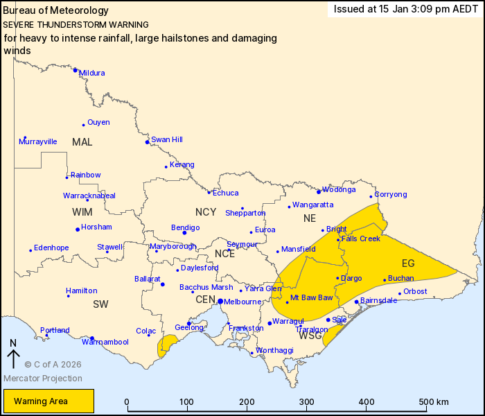
Source: Bureau of Meteorology
For people in East Gippsland and parts of North East, West and
South Gippsland, Central, South West and North Central Forecast
Districts.
Issued at 3:09 pm Thursday, 15 January 2026.
INTENSE RAINFALL RISK CONTINUING ALONG THE GIPPSLAND COAST, SEVERE
STORMS IN THE EAST AND OTWAYS.
Weather Situation: An upper-level low pressure system is
generating slow moving showers and thunderstorms over the Otways,
Gippsland coast and eastern ranges. Severe thunderstorms are also
continuing to develop in the east with the additional hazards of
large hail and damaging winds.
VERY DANGEROUS THUNDERSTORMS are likely to produce intense
rainfall that may lead to dangerous and life-threatening flash
flooding over the next several hours in parts of the West and South
Gippsland district. Locations which may be affected include
Seaspray.
Severe thunderstorms are likely to produce heavy rainfall that may
lead to flash flooding over the next several hours in parts of the
Central and South West districts. Locations which may be affected
include Lorne and surrounds.
Severe thunderstorms are likely to produce heavy rainfall that may
lead to flash flooding, large hailstones and damaging winds over
the next several hours in the East Gippsland and parts of the North
East, West and South Gippsland, Central and North Central
districts. Locations which may be affected include Falls Creek,
Dargo, Buchan, Mt Baw Baw, Maffra, Mt Hotham, Omeo, Chandlers Creek
and Combienbar.
Significant rainfall observations to 3:00 pm:
175.4 MM AT MT COWLEY IN THE 6 HOURS TO 3:00 PM.
52.4 MM AT BENWERRIN IN THE 1 HOUR TO 2:00 PM.
23.6 mm at Aireys Inlet in the 1 hour to 2:20 pm.
The State Emergency Service advises that people should:
* If driving conditions are dangerous, safely pull over away from
trees, drains, low-lying areas and floodwater. Avoid travel if
possible.
* Stay safe by avoiding dangerous hazards, such as floodwater,
mud, debris, damaged roads and fallen trees.
* Be aware - heat, fire or recent storms may make trees unstable
and more likely to fall when it's windy or wet.
* Check that loose items, such as outdoor settings, umbrellas and
trampolines are safely secured. Move vehicles under cover or away
from trees.
* Stay indoors and away from windows.
* If outdoors, move to a safe place indoors. Stay away from trees,
drains, gutters, creeks and waterways.
* Stay away from fallen powerlines - always assume they are
live.
* Be aware that in fire affected areas, rainfall run-off into
waterways may contain debris such as ash, soil, trees and rocks.
Heavy rainfall may also increase the potential for landslides and
debris across roads.
* Stay informed: Monitor weather warnings, forecasts and river
levels at the Bureau of Meteorology website, and warnings through
VicEmergency website/app/hotline.
15/Jan/2026 04:17 AM

