
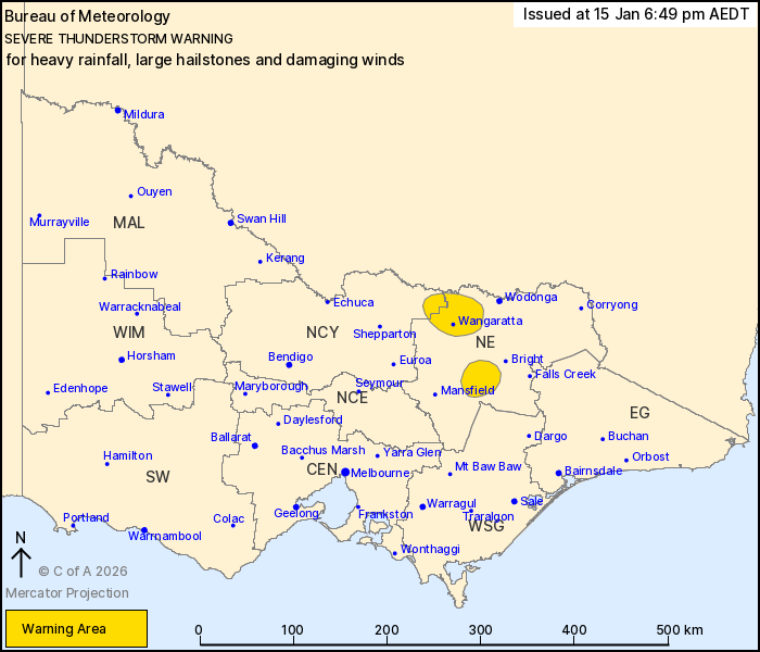
Source: Bureau of Meteorology
For people in parts of North East and Northern Country Forecast
Districts.
Issued at 6:49 pm Thursday, 15 January 2026.
Isolated severe storms persist in the northeast this
evening.
Weather Situation: An upper-level low pressure system is
continuing to generate isolated slow moving showers and
thunderstorms across the northeast this evening. Heavy falls are
likely here, though the likelihood of large hailstones and damaging
winds is diminishing over the next hour.
Severe thunderstorms are likely to produce heavy rainfall that may
lead to flash flooding, possibly large hailstones and damaging
winds in the warning area over the next several hours. Locations
which may be affected include Wangaratta.
Severe thunderstorms are no longer occurring in the East
Gippsland, North Central and West and South Gippsland districts and
the warning for these districts is CANCELLED.
A separate Severe Weather Warning is current at the time of issue
for damaging winds about parts of the state.
Check
https://www.bom.gov.au/weather-and-climate/warnings-and-alerts.
Warnings are also available through TV and Radio broadcasts or call
1300 659 210. The Bureau and State Emergency Service would
appreciate warnings being broadcast regularly.
Significant rainfall observations:
50.6 MM AT THE GORGE (GENOA RIVER) IN THE 1 HOUR TO 5;15 PM.
67.0 MM AT MT CANN FIRE TOWER IN THE 1 HOUR TO 4:06 PM.
59.8 MM AT LICOLA IN THE 1 HOUR TO 3:37 PM.
176.2 MM AT MT COWLEY IN THE 6 HOURS TO 3:00 PM.
88.4 MM AT BENWERRIN IN THE 3 HOUR TO 3:00 PM.
The State Emergency Service advises that people should:
* If driving conditions are dangerous, safely pull over away from
trees, drains, low-lying areas and floodwater. Avoid travel if
possible.
* Stay safe by avoiding dangerous hazards, such as floodwater,
mud, debris, damaged roads and fallen trees.
* Be aware - heat, fire or recent storms may make trees unstable
and more likely to fall when it's windy or wet.
* Check that loose items, such as outdoor settings, umbrellas and
trampolines are safely secured. Move vehicles under cover or away
from trees.
* Stay indoors and away from windows.
* If outdoors, move to a safe place indoors. Stay away from trees,
drains, gutters, creeks and waterways.
* Stay away from fallen powerlines - always assume they are
live.
* Be aware that in fire affected areas, rainfall run-off into
waterways may contain debris such as ash, soil, trees and rocks.
Heavy rainfall may also increase the potential for landslides and
debris across roads.
* Stay informed: Monitor weather warnings, forecasts and river
levels at the Bureau of Meteorology website, and warnings through
VicEmergency website/app/hotline.
15/Jan/2026 09:18 AM

