
Source: Bureau of Meteorology
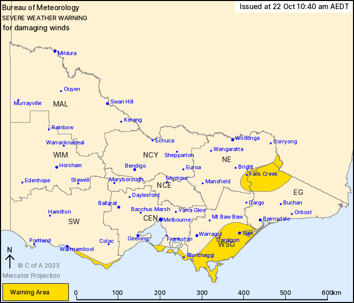
For people in parts of East Gippsland, North East, West and South
Gippsland, Central and South West Forecast Districts.
Issued at 10:40 am Sunday, 22 October 2023.
Damaging wind gusts are forecast over southern Victoria and also
elevated terrain in the northeast during Sunday.
Weather Situation: Northwest to southwesterly winds will
strengthen as a low pressure system moves east through Bass Strait
during Sunday, before reaching the Tasman Sea early Monday
morning.
For SOUTH WEST COAST: Strong northwest to southwesterly winds
averaging 50 to 60 km/h with DAMAGING WIND GUSTS of around 90 km/h
are possible along the coast fringe east of Warrnambool today,
gradually easing during the afternoon.
For elevated areas in the far NORTHEAST and EAST GIPPSLAND: Strong
west to northwesterly winds averaging 50 to 60 km/h with DAMAGING
WIND GUSTS of around 90km/h are possible from Sunday afternoon,
easing during the late evening.
For SOUTHEAST CENTRAL and WEST AND SOUTH GIPPSLAND: Strong
northwest to southwesterly winds averaging 50 to 60 km/h with
DAMAGING WIND GUSTS of around 90 km/h are possible from Sunday
afternoon, easing during the evening.
Locations which may be affected include Wonthaggi, Rosebud,
Morwell, Traralgon, Sale, Maffra, Falls Creek, Mt Hotham and
Omeo.
91 km/h wind gust was recorded at Aireys Inlet at 12:48 am.
The State Emergency Service advises that people should:
* If driving conditions are dangerous, safely pull over away from
trees, drains, low-lying areas and floodwater. Avoid travel if
possible.
* Stay safe by avoiding dangerous hazards, such as floodwater,
mud, debris, damaged roads and fallen trees.
* Be aware - heat, fire or recent storms may make trees unstable
and more likely to fall when it's windy or wet.
* Check that loose items, such as outdoor settings, umbrellas and
trampolines are safely secured. Move vehicles under cover or away
from trees.
* Stay indoors and away from windows.
* If outdoors, move to a safe place indoors. Stay away from trees,
drains, gutters, creeks and waterways.
* Stay away from fallen powerlines - always assume they are
live.
* Be aware that in fire affected areas, rainfall run-off into
waterways may contain debris such as ash, soil, trees and rocks.
Heavy rainfall may also increase the potential for landslides and
debris across roads.
* Stay informed: Monitor weather warnings, forecasts and river
levels at the Bureau of Meteorology website, and warnings through
VicEmergency website/app/hotline.
22/Oct/2023 12:20 AM

