
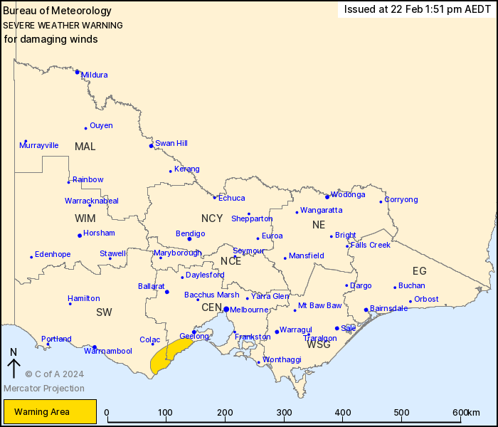
Source: Bureau of Meteorology
For people in parts of Central and South West Forecast
Districts.
Issued at 1:51 pm Thursday, 22 February 2024.
Gusty winds about the Otways and Surf Coast this afternoon.
Weather Situation: A strong cold front approaching the west of the
state is directing gusty northwesterly winds ahead of it before a
cooler southwesterly change arrives in the late afternoon.
DAMAGING WIND GUSTS of around 90 km/h are likely about the Otways
and Surf Coast, with winds likely to ease by late Thursday
afternoon.
Locations which may be affected include Lorne, Aireys Inlet and
Apollo Bay.
A 96 km/h wind gust was recorded at Aireys Inlet at 1:33 pm.
The State Emergency Service advises that people should:
* If driving conditions are dangerous, safely pull over away from
trees, drains, low-lying areas and floodwater. Avoid travel if
possible.
* Stay safe by avoiding dangerous hazards, such as floodwater,
mud, debris, damaged roads and fallen trees.
* Be aware - heat, fire or recent storms may make trees unstable
and more likely to fall when it's windy or wet.
* Check that loose items, such as outdoor settings, umbrellas and
trampolines are safely secured. Move vehicles under cover or away
from trees.
* Stay indoors and away from windows.
* If outdoors, move to a safe place indoors. Stay away from trees,
drains, gutters, creeks and waterways.
* Stay away from fallen powerlines - always assume they are
live.
* Be aware that in fire affected areas, rainfall run-off into
waterways may contain debris such as ash, soil, trees and rocks.
Heavy rainfall may also increase the potential for landslides and
debris across roads.
* Stay informed: Monitor weather warnings, forecasts and river
levels at the Bureau of Meteorology website, and warnings through
VicEmergency website/app/hotline.
22/Feb/2024 02:58 AM


