
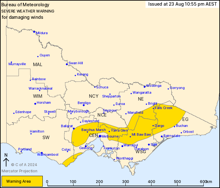
Source: Bureau of Meteorology
For people in parts of Central, East Gippsland, North Central,
North East, West and South Gippsland and South West Forecast
Districts.
Issued at 10:55 pm Friday, 23 August 2024.
Damaging wind gusts likely overnight into Saturday morning.
Weather Situation: An approaching surface trough will lead to a
strengthening the north to northwesterly winds across elevated
areas and their immediate downwind slopes tonight. These winds will
ease throughout Saturday morning as the trough clears to the
east.
Strong winds averaging 50 to 60 km/h with DAMAGING WIND GUSTS of
around 90 km/h are likely to develop in the next hour or two and
through the early morning of Saturday, possibly reaching up to 110
km/h over the northeast ranges and associated lee slopes.
Winds are expected to ease over the Otways and the Central
District by sunrise Saturday, and over eastern districts by
Saturday afternoon.
Locations which may be affected include Mt Dandenong, Apollo Bay,
Yarra Glen, Bacchus Marsh, Dargo, Gelantipy, Mt Baw Baw, Falls
Creek, Mt Hotham, Mt Buller and Omeo.
The State Emergency Service advises that people should:
* If driving conditions are dangerous, safely pull over away from
trees, drains, low-lying areas and floodwater. Avoid travel if
possible.
* Stay safe by avoiding dangerous hazards, such as floodwater,
mud, debris, damaged roads and fallen trees.
* Be aware - heat, fire or recent storms may make trees unstable
and more likely to fall when it's windy or wet.
* Check that loose items, such as outdoor settings, umbrellas and
trampolines are safely secured. Move vehicles under cover or away
from trees.
* Stay indoors and away from windows.
* If outdoors, move to a safe place indoors. Stay away from trees,
drains, gutters, creeks and waterways.
* Stay away from fallen powerlines - always assume they are
live.
* Be aware that in fire affected areas, rainfall run-off into
waterways may contain debris such as ash, soil, trees and rocks.
Heavy rainfall may also increase the potential for landslides and
debris across roads.
* Stay informed: Monitor weather warnings, forecasts and river
levels at the Bureau of Meteorology website, and warnings through
VicEmergency website/app/hotline.
23/Aug/2024 01:10 PM

