
Source: Bureau of Meteorology
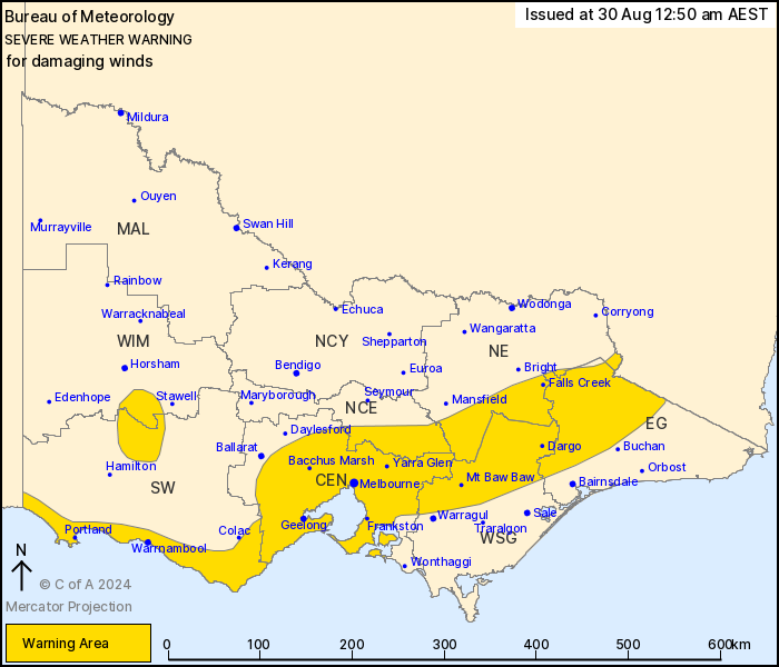
For people in Central and parts of East Gippsland, South West,
North Central, North East, West and South Gippsland and Wimmera
Forecast Districts.
Issued at 12:50 am Friday, 30 August 2024.
Damaging winds have redeveloped over parts of Victoria.
Weather Situation: A strong cold front is moving through the
centre of the state overnight and clearing to the east by late
Friday morning. A vigorous westerly airstream is then expected to
develop in the wake of the front over the south, ahead of a second
front sweeping over southern parts of the state overnight and
during early Saturday morning.
FOR THE GRAMPIANS, CENTRAL RANGES and the NORTHEAST RANGES:
DAMAGING NORTH TO NORTHWESTERLY WINDS, averaging 60 to 70 km/h with
peak gusts to 100 km/h are likely during Friday morning. Wind gusts
are likely to reach 120 km/h about the elevated terrain over the
Northeast Ranges. Conditions will gradually ease over the Grampians
and inland Central Districts by sunrise and then over the Northeast
Ranges during Friday afternoon.
FOR THE SOUTHWEST COAST, OTWAY RANGES, GREATER GEELONG AREA,
MELBOURNE and MORNINGTON PENINSULA: DAMAGING WEST TO NORTHWESTERLY
WINDS averaging 50 to 65 km/h with peak gusts of around 100 km/h
are likely during early Friday morning. DAMAGING WIND GUSTS could
reach up to 120 km/h along the Southwest Coast, especially with
showers, during early Friday morning. Winds are expected to ease
for a period from sunrise before isolated DAMAGING WIND GUSTS
reaching to 90 km/h are again possible in shower activity along the
Southwest Coast and Greater Geelong Area during Friday
afternoon.
During late Friday night, expect another period of DAMAGING WIND
GUSTS to develop over southern parts of the state, which will
likely see the warning areas continue over the southwest and extend
to parts of West and South Gippsland.
A Coastal Hazard Warning is also current for the Victoria
coastline. Please refer to
http://www.bom.gov.au/vic/warnings/
Locations which may be affected include Warrnambool, Portland,
Geelong, Melbourne, all of Mornington Peninsula including
Frankston, Bacchus Marsh, Falls Creek, Mt Buller and Omeo.
98 km/h wind gust was recorded at Mount Hotham at 9:30 pm.
91 km/h wind gust was recorded at Mount Buller at 10:10 pm.
93 km/h wind gust was recorded at Melbourne Airport at 11:13
pm.
95 km/h wind gust was recorded at St Kilda Harbour at 11:53
pm.
120 km/h wind gust was recorded at Warrnambool Airport at 11:50
pm.
115 km/h wind gust was recorded at Mount William at 00:25
am.
111 km/h wind gust was recorded at Mount Gellibrand at 00:40
am.
The State Emergency Service advises that people should:
* If driving conditions are dangerous, safely pull over away from
trees, drains, low-lying areas and floodwater. Avoid travel if
possible.
* Stay safe by avoiding dangerous hazards, such as floodwater,
mud, debris, damaged roads and fallen trees.
* Be aware - heat, fire or recent storms may make trees unstable
and more likely to fall when it's windy or wet.
* Check that loose items, such as outdoor settings, umbrellas and
trampolines are safely secured. Move vehicles under cover or away
from trees.
* Stay indoors and away from windows.
* If outdoors, move to a safe place indoors. Stay away from trees,
drains, gutters, creeks and waterways.
* Stay away from fallen powerlines - always assume they are
live.
* Be aware that in fire affected areas, rainfall run-off into
waterways may contain debris such as ash, soil, trees and rocks.
Heavy rainfall may also increase the potential for landslides and
debris across roads.
* Stay informed: Monitor weather warnings, forecasts and river
levels at the Bureau of Meteorology website, and warnings through
VicEmergency website/app/hotline.
29/Aug/2024 03:00 PM

