
Source: Bureau of Meteorology
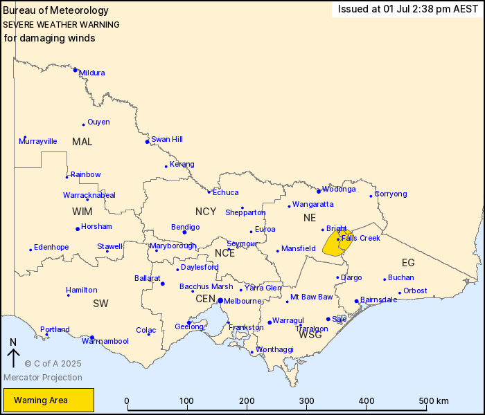
For people in parts of East Gippsland and North East Forecast
Districts.
Issued at 2:38 pm Tuesday, 1 July 2025.
Damaging winds expected over northeast alpine areas from this
evening into tomorrow morning.
Weather Situation: A deepening low off the New South Wales coast
and a high over inland Australia are expected to produce a vigorous
southeasterly airstream over the northeast Victorian alpine peaks
this evening into Wednesday morning.
DAMAGING WINDS averaging 60 to 70 km/h with peak gusts around 100
km/h are likely in the warning area from this evening until late
Wednesday morning.
Locations which may be affected include Falls Creek and Mt
Hotham.
The State Emergency Service advises that people should:
* If driving conditions are dangerous, safely pull over away from
trees, drains, low-lying areas and floodwater. Avoid travel if
possible.
* Stay safe by avoiding dangerous hazards, such as floodwater,
mud, debris, damaged roads and fallen trees.
* Be aware - heat, fire or recent storms may make trees unstable
and more likely to fall when it's windy or wet.
* Check that loose items, such as outdoor settings, umbrellas and
trampolines are safely secured. Move vehicles under cover or away
from trees.
* Stay indoors and away from windows.
* If outdoors, move to a safe place indoors. Stay away from trees,
drains, gutters, creeks and waterways.
* Stay away from fallen powerlines - always assume they are
live.
* Be aware that in fire affected areas, rainfall run-off into
waterways may contain debris such as ash, soil, trees and rocks.
Heavy rainfall may also increase the potential for landslides and
debris across roads.
* Stay informed: Monitor weather warnings, forecasts and river
levels at the Bureau of Meteorology website, and warnings through
VicEmergency website/app/hotline.
01/Jul/2025 04:43 AM


