
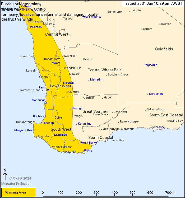
Source: Bureau of Meteorology
For people in Central West, Lower West, South West and parts of
South Coastal, Great Southern and Central Wheat Belt
districts.
Issued at 10:29 am Saturday, 1 June 2024.
COLD FRONT TO BRING SEVERE WEATHER TO THE WEST COAST LATER TODAY,
EASING BY SUNDAY NIGHT.
Weather Situation: A vigorous cold front is slowly approaching the
West Coast today, with heavy rainfall and very gusty thunderstorms
expected to sweep across much of the southwest tonight, spreading
north and inland into Sunday morning. Severe conditions should ease
throughout most areas by late Sunday morning as the front moves
inland. A vigorous west to southwesterly airstream is expected to
persist about the coastal strip south of Mandurah and the South
West and South Coastal districts into Sunday evening.
HEAVY RAINFALL which may lead to FLASH FLOODING is possible across
the South West district from late Saturday afternoon or early
evening, spreading to the Lower West and Central West districts by
late Saturday evening or early Sunday morning. Six-hourly rainfall
totals between 45 to 65 mm are possible. HEAVY RAINFALL is expected
to ease by mid-morning on Sunday.
Locally INTENSE RAINFALL which may lead to DANGEROUS AND
LIFE-THREATENING FLASH FLOODING is also possible over parts of the
South West, Lower West and Central West districts. This risk is
initially south of Mandurah during Saturday evening, but extends
further north to Perth and about Jurien Bay during early Sunday
morning. Six-hourly rainfall totals between 75 to 90 mm are
possible. The risk of INTENSE RAINFALL is likely to ease by sunrise
on Sunday.
A separate Severe Thunderstorm Warning will be issued if very
dangerous thunderstorms with intense rainfall are detected.
DAMAGING WINDS, averaging 60 to 70 km/h with peak gusts to around
100 km/h are possible from later this afternoon in the South West
district, spreading to the Lower West and Central West districts by
late this evening or early Sunday morning. DAMAGING WINDS should
ease throughout most districts by mid-morning on Sunday, but are
expected to persist about the coastal strip south of Mandurah and
in the South West and South Coastal districts until late Sunday
evening.
Locally DESTRUCTIVE WINDS with peak gusts in excess of 125 km/h
are also possible from late today into early Sunday morning along
the coast with isolated stronger thunderstorms, and could cause
SIGNIFICANT DAMAGE OR DESTRUCTION TO HOMES AND PROPERTY.
People in the southwest of WA experience a front as windy as this
about 3 to 5 times per year. Rainfall totals this weekend are also
expected to be higher than those from a typical winter front.
Locations which may be affected include Albany, Bunbury,
Busselton, Geraldton, Kalbarri, Mandurah, Manjimup, Margaret River,
Moora, Mount Barker, Narrogin, Northam and Perth.
The Department of Fire and Emergency Services advises that people
should:
* If outside find safe shelter away from trees, power lines, storm
water drains and streams.
* Close your curtains and blinds, and stay inside away from
windows.
* Unplug electrical appliances and do not use land line telephones
if there is lightning.
* If boating, swimming or surfing leave the water.
* Be alert and watch for hazards on the road such as fallen power
lines and loose debris.
* Keep away from flooded drains, rivers, streams and
waterways.
* Be careful of fallen trees, damaged buildings and debris.
* Be careful of fallen power lines. They are dangerous and should
always be treated as live.
* Assess your home, car and property for damage.
* If damage has occurred take photos and contact your insurance
company to organise permanent repairs.
* If your home or property has significant damage, like a badly
damaged roof or flooding, call the SES on 132 500.
01/Jun/2024 02:40 AM

