
Source: Bureau of Meteorology
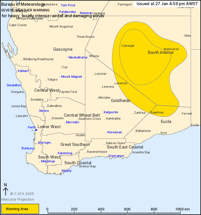
For people in parts of Goldfields, Eucla and South Interior
districts.
Issued at 4:59 pm Tuesday, 27 January 2026.
HEAVY TO INTENSE RAINFALL AND DAMAGING WINDS CONTINUE AS
EX-TROPICAL CYCLONE LUANA MOVES SOUTH.
Weather Situation: Ex Tropical Cyclone Luana is continuing to move
steadily to the south southeast this evening. Severe weather is
likely in the South Interior this evening before spreading further
south overnight and into Wednesday as it interacts with an
approaching upper trough and cold front.
DAMAGING WIND GUSTS of about 90 km/h are possible near the centre
of the system and towards the Northern Territory/South Australia
border for the remainder of today, particularly in
thunderstorms.
HEAVY RAINFALL which may lead to FLASH FLOODING is likely
throughout the South Interior, reaching into eastern Goldfields and
northern Eucla overnight into Wednesday. 6-hourly totals between 60
and 80 mm are likely with 24-hourly totals between 80 and 130 mm
likely.
Locally INTENSE RAINFALL may develop through central parts of the
South Interior district this afternoon and evening, with 6-hour
rainfall up to 120 mm and 24-hour rainfall totals approaching 180
mm possible.
INTENSE RAINFALL is likely to ease over the South Interior by
Wednesday afternoon, while remaining severe weather is likely to
ease by Wednesday evening.
Flood Watches and Warnings are current for the area. For more
information, refer to
https://www.bom.gov.au/weather-and-climate/warnings-and-alerts
Locations which may be affected include Carnegie and
Warburton.
Severe weather is no longer occurring in the North Interior
district and the warning for this district is CANCELLED.
100 km/h wind gust was recorded at Giles at 3:19 pm.
The Department of Fire and Emergency Services advises that people
should:
* If outside find safe shelter away from trees, power lines, storm
water drains and streams.
* Close your curtains and blinds, and stay inside away from
windows.
* Unplug electrical appliances and do not use land line telephones
if there is lightning.
* If boating, swimming or surfing leave the water.
* Be alert and watch for hazards on the road such as fallen power
lines and loose debris.
* Keep away from flooded drains, rivers, streams and
waterways.
* Be careful of fallen trees, damaged buildings and debris.
* Be careful of fallen power lines. They are dangerous and should
always be treated as live.
* Assess your home, car and property for damage.
* If damage has occurred take photos and contact your insurance
company to organise permanent repairs.
* If your home or property has significant damage, like a badly
damaged roof or flooding, call the SES on 132 500.
27/Jan/2026 09:13 AM

