
Source: Bureau of Meteorology
For people in parts of Lower West and South West districts.
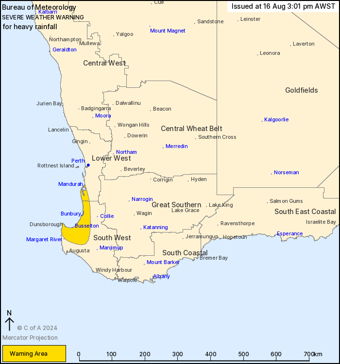
Issued at 3:01 pm Friday, 16 August 2024.
Heavy falls possible from Geographe Bay to Mandurah on
Saturday.
Weather Situation: a cold front will become slow-moving just
offshore of the South West coast overnight, with areas of rain and
thunderstorms expected to push ashore throughout Saturday
morning.
HEAVY RAINFALL which may lead to FLASH FLOODING is possible
between Cape Naturaliste and Mandurah during Saturday morning. 6
hourly rainfall totals may reach up to 60 mm in isolated areas.
Rainfall is expected to ease in the warning area early on Saturday
afternoon.
A low pressure system will deepen over the Southern Ocean close to
the WA coast during Sunday. Further warnings are possible for
southwest parts of the state. Stay up to date at:
http://www.bom.gov.au/wa/warnings/
Locations which may be affected include Bunbury, Busselton,
Mandurah, Dunsborough and Harvey.
The Department of Fire and Emergency Services advises that people
should:
* If outside find safe shelter away from trees, power lines, storm
water drains and streams.
* Close your curtains and blinds, and stay inside away from
windows.
* Unplug electrical appliances and do not use land line telephones
if there is lightning.
* If boating, swimming or surfing leave the water.
* Be alert and watch for hazards on the road such as fallen power
lines and loose debris.
* Keep away from flooded drains, rivers, streams and
waterways.
* Be careful of fallen trees, damaged buildings and debris.
* Be careful of fallen power lines. They are dangerous and should
always be treated as live.
* Assess your home, car and property for damage.
* If damage has occurred take photos and contact your insurance
company to organise permanent repairs.
* If your home or property has significant damage, like a badly
damaged roof or flooding, call the SES on 132 500.
16/Aug/2024 07:08 AM

