
Source: Bureau of Meteorology
Issued at 11:43 am WST on Saturday 24 January 2026
Headline:
Tropical Cyclone Luana impacting the northwest Kimberley
coast.
Areas Affected:
Warning zone: Broome to Kuri Bay, including Derby and adjacent
inland areas.
Watch zone: None.
Cancelled zone: None.
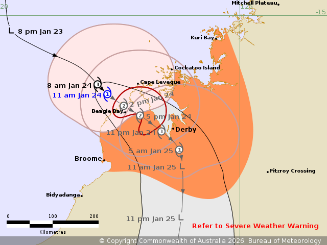
Details of Tropical Cyclone Luana 16U at 11:00 am AWST:
Intensity: Category 1, sustained winds near the centre of 85
kilometres per hour with wind gusts to 120 kilometres per
hour.
Location: within 30 kilometres of 16.6 degrees South 122.3 degrees
East, estimated to be 70 kilometres west southwest of Cape Leveque
and 150 kilometres north of Broome.
Movement: southeast at 13 kilometres per hour.
Tropical Cyclone Luana is drawing close to the Dampier Peninsula
coast between Beagle Bay and Cape Leveque, and the centre is likely
to cross in the next 3 to
6 hours. Wind and rain impacts are already occurring about the
northern Dampier Peninsula and should extend south this afternoon
and overnight.
Luana remains a category 1 system but is forecast to strengthen to
category 2 just prior to crossing the coast this afternoon between
Beagle Bay and Cape Leveque.
After landfall, Luana may remain near or move back over the waters
of King Sound, and may maintain category 2 intensity until it is
close to Derby tonight. It will weaken below tropical cyclone
strength during Sunday morning after moving further inland.
Hazards:
DESTRUCTIVE WIND GUSTS to 130 km/h may develop near the system
centre between Beagle Bay and Cockatoo Island today as the system
approaches and moves over the coast. These DESTRUCTIVE WIND GUSTS
may extend to Derby tonight if the system maintains strength longer
than forecast.
GALES with DAMAGING WIND GUSTS to 120 km/h are currently occurring
between Beagle Bay and Kuri Bay. These gales may extend south to
Derby and Broome this afternoon, and to adjacent inland areas
overnight tonight.
HEAVY RAINFALL which may lead to FLASH FLOODING is possible for
the northwest Kimberley district, including the coast and adjacent
inland areas today.
Coastal residents within King Sound are specifically warned of the
potential for a DANGEROUS STORM TIDE as the cyclone passes close to
the Sound. Tides are likely to rise significantly above the normal
high tide, with DAMAGING WAVES and DANGEROUS FLOODING.
Tides will be higher than normal between Beagle Bay and Kuri Bay
today and LARGE WAVES may produce MINOR FLOODING of low-lying
coastal areas as the system crosses the coast.
A separate Severe Weather Warning is current for peripheral areas
in the Kimberley.
Recommended Action:
Ensure you know what to do in a cyclone. For the latest DFES
community alerts and warnings visit www.emergency.wa.gov.au or
download the Emergency WA app.
Current
Tropical Cyclones
24/Jan/2026 03:52 AM

