
Source: Bureau of Meteorology
TROPICAL CYCLONE ADVICE NUMBER 6
Issued at 2:45 pm WST on Monday 29 December 2025
Headline:
Tropical Cyclone Hayley forecast to be a severe impact to the
northern Dampier Peninsula on the west Kimberley coast later
Tuesday.
Areas Affected:
Warning Zone
Dampier Peninsula north of Broome to Cape Leveque and east to
Cockatoo Island.
Watch Zone
Derby to Kuri Bay
Cancelled Zone
Broome.
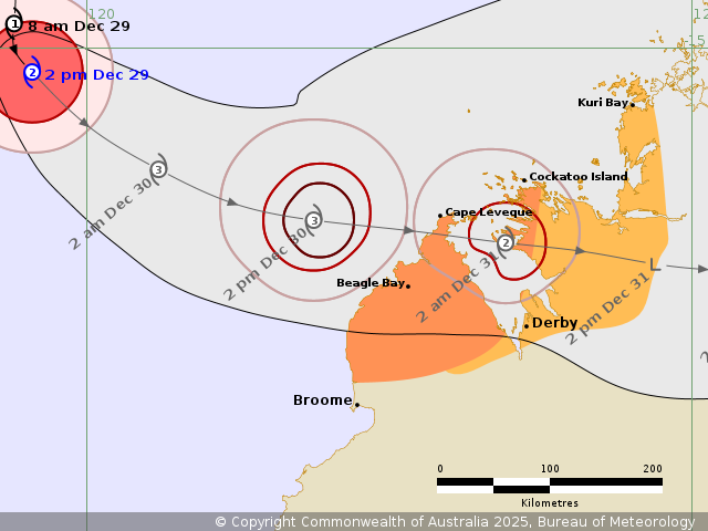
Details of Tropical Cyclone Hayley 08U at 2:00 pm AWST:
Intensity: Category 2, sustained winds near the centre of 100
kilometres per hour with wind gusts to 140 kilometres per
hour.
Location: within 35 kilometres of 15.2 degrees South 119.5 degrees
East, estimated to be 385 kilometres west northwest of Cape Leveque
and 420 kilometres northwest of Broome.
Movement: south southeast at 10 kilometres per hour.
Tropical Cyclone Hayley is northwest of the Kimberley coast, is
now category 2 intensity and strengthening and it is starting to
move southeast towards the coast.
Hayley is forecast to move east southeast during Tuesday and reach
the northern part of the Dampier Peninsula late in the day.
Hayley is forecast to intensify to a severe category 3 cyclone
overnight tonight. It now appears more likely to maintain category
3 intensity to landfall even if some weakening occurs prior to
then.
Hazards:
VERY DESTRUCTIVE WIND GUSTS to 200 km/h are possible about the
northern Dampier Peninsula including Beagle Bay and Cape Leveque
from Tuesday evening.
DESTRUCTIVE WIND GUSTS to 150 km/h are likely to develop about the
northern Dampier Peninsula north of Broome to Cape Leveque from
late Tuesday afternoon.
GALES with DAMAGING WIND GUSTS to 100 km/h may develop over the
Dampier Peninsula north of Broome as early as late Tuesday morning,
extending east to Cockatoo Island later Tuesday. Gales may then
extend further east to Kuri Bay early Wednesday.
HEAVY RAINFALL which may lead to FLASH FLOODING is possible near
the track for the area under Warning and Watch from Tuesday.
Tides will be higher than normal as Hayley approaches the west
Kimberley Coast.
Recommended Action:
DFES Advises: Ensure you know what to do in a cyclone. For the
latest
Current
Tropical Cyclones
29/Dec/2025 07:00 AM

