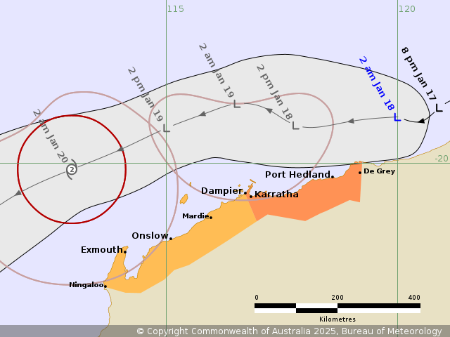
Source: Bureau of Meteorology
Issued at 2:41 am WST on Saturday 18 January 2025
Headline:
A tropical low (11U) is likely to develop into a tropical cyclone
north of the Pilbara this weekend, with peripheral impacts along
the Pilbara coast.
Areas Affected:
Warning Zone
De Grey to Dampier, including Port Hedland, Karratha, and
Dampier.
Watch Zone
Ningaloo to Dampier, including Onslow and Exmouth.
Cancelled Zone
None.
A tropical low has formed to the north of the Pilbara coast. The
environment is conducive to development and the low has a high
chance of developing into a tropical cyclone on Sunday. The
developing low is expected to move on a westward track, parallel to
the coast, remaining offshore to the north of the Pilbara during
the weekend. Early next week, the cyclone is expected to continue
on a southwest track, moving well away from the WA mainland
coast.
Hazards:
GALES with DAMAGING WIND GUSTS may develop about coastal and
island communities between De Grey and Dampier from early Sunday as
the low intensifies to the north of the coast.
GALES with DAMAGING WIND GUSTS may extend from Dampier to Exmouth
overnight Sunday and Exmouth to Ningaloo early Monday as the system
moves further west.
As the system moves westwards, parallel to north WA coast during
the weekend, a storm tide is expected between De Grey and Exmouth
during Sunday and Monday. Large waves may produce minor flooding
along the foreshore. People living in areas likely to be affected
by this flooding should take measures to protect their property as
much as possible and be prepared to help their neighbours.
Recommended Action:
Ensure you know what to do in a cyclone. For the latest DFES
community alerts and warnings visit emergency.wa.gov.au or download
the Emergency WA app.
Current
Tropical Cyclones

17/Jan/2025 09:54 PM


