
Source: Bureau of Meteorology
TROPICAL CYCLONE ADVICE NUMBER 3
Issued at 11:48 pm WST on Thursday 27 March 2025
Headline:
Tropical Cyclone risk for the northwest Kimberley coast, between
Mitchell Plateau and Beagle Bay from Friday night.
Areas Affected:
Warning Zone
Mitchell Plateau to Beagle Bay including Derby.
Watch Zone
None.
Cancelled Zone
None.
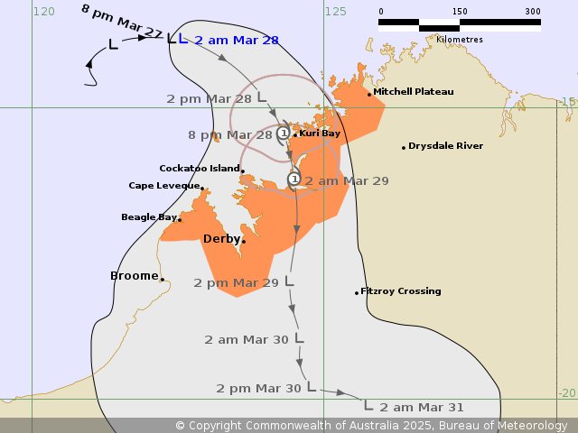
Details of Tropical Low 28U at 11:00 pm AWST:
Intensity: Tropical Low, sustained winds near the centre of 55
kilometres per hour with wind gusts to 85 kilometres per
hour.
Location: within 45 kilometres of 13.9 degrees South 122.6 degrees
East, estimated to be 270 kilometres northwest of Kuri Bay and 395
kilometres north northwest of Derby.
Movement: east southeast at 9 kilometres per hour.
Tropical low 28U is developing to the northwest of the Kimberley.
It is currently moving to the east but expected to turn to the
south during Friday. It is forecast to reach tropical cyclone
intensity before crossing the Kimberley coast overnight Friday
night or Saturday morning, most likely north of Derby between Kuri
Bay and Beagle Bay. Later Saturday and during Sunday 28U is likely
to be weakening over land.
Hazards:
Gales with DAMAGING WIND GUSTS to 100 kilometres per hour likely
to develop in coastal areas between Kuri Bay and Beagle Bay during
Friday evening and Saturday morning, possibly extending as far east
as Mitchell Plateau. Gales are less likely at Derby, the highest
risk period being during Saturday.
HEAVY RAINFALL which may lead to FLASH FLOODING is possible in
parts of the northern and western Kimberley from Friday, extending
further inland during the weekend.
Recommended Action:
Ensure you know what to do in a cyclone. For the latest DFES
community alerts and warnings visit www.emergency.wa.gov.au or
download the Emergency WA app.
Current
Tropical Cyclones
27/Mar/2025 08:56 PM

