
Source: Bureau of Meteorology
Issued at 2:40 pm WST on Sunday 28 December 2025
Headline:
Tropical Low 08U to develop into a tropical cyclone, and approach
the west Kimberley coast during Tuesday.
Areas Affected:
Warning Zone
None.
Watch Zone
Broome to Cockatoo Island, including Derby.
Cancelled Zone
None.
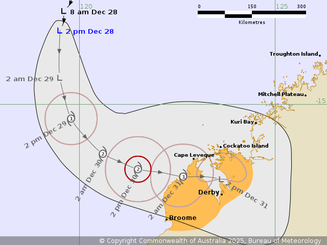
Details of Tropical Low 08U at 2:00 pm AWST:
Intensity: Tropical Low, sustained winds near the centre of 55
kilometres per hour with wind gusts to 85 kilometres per
hour.
Location: within 30 kilometres of 13.1 degrees South 119.5 degrees
East, estimated to be 620 kilometres north northwest of Broome and
650 kilometres northwest of Derby.
Movement: south at 9 kilometres per hour.
Tropical Low 08U is currently located well northwest of the
Kimberley coast and is strengthening as it drifts southward.
It is forecast to develop into a tropical cyclone Monday morning
and turn to the southeast, towards the western Kimberley coast. It
is forecast to maintain this track through Tuesday and into
Wednesday.
From late Tuesday, atmospheric conditions become unfavourable for
the system to develop further, and 08U may be weakening as it
approaches the western Kimberley coast Tuesday night or
Wednesday.
Hazards:
GALES with DAMAGING WIND GUSTS to 90 km/h are possible for the
watch area during Tuesday.
DESTRUCTIVE WIND GUSTS are possible about the coastal fringe north
of Broome to Cape Leveque late Tuesday, if the system moves faster
than forecast.
Widespread moderate to locally HEAVY RAINFALL which may lead to
FLASH FLOODING is possible for the watch area from Tuesday.
Tides will be higher than normal as 08U approaches the west
Kimberley Coast.
Recommended Action:
DFES Advises: Ensure you know what to do in a cyclone. For the
latest DFES community alerts and warnings visit
www.emergency.wa.gov.au or download the Emergency WA app.
Current
Tropical Cyclones
28/Dec/2025 06:55 AM

