
Source: Bureau of Meteorology
Issued at 8:47 am WST on Thursday 22 January 2026
Headline:
Tropical Low (16U) has a high risk of developing into a tropical
cyclone as it approaches the northwest Kimberley Coast on
Saturday.
Areas Affected:
Warning zone: None.
Watch zone: Mitchell Plateau to Bidyadanga, including Broome and
Derby.
Cancelled zone: None.
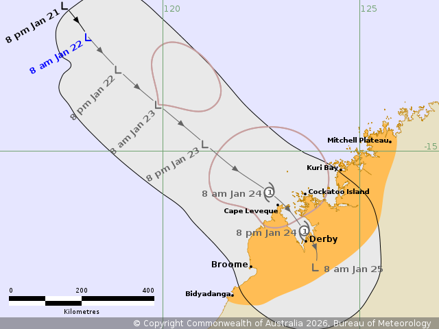
Details of Tropical Low 16U at 8:00 am AWST:
Intensity: Tropical Low, sustained winds near the centre of 35
kilometres per hour with wind gusts to 85 kilometres per
hour.
Location: within 95 kilometres of 12.1 degrees South 118.1 degrees
East, estimated to be 790 kilometres northwest of Broome and 830
kilometres northwest of Derby.
Movement: south southeast at 7 kilometres per hour.
Tropical Low (16U) lies over waters to the northwest of the
Kimberley coast.
The system is forecast to intensify further as it tracks southeast
today and on Friday, towards the northwest Kimberley coast.
16U is expected to reach tropical cyclone strength overnight
Friday or early Saturday morning, before crossing the northwest
Kimberley coast during Saturday as a category 1 system. During
Sunday, 16U is forecast to track through the Kimberley as a
tropical low.
Hazards:
GALES with DAMAGING WIND GUSTS to 120 km/h are possible between
Mitchell Plateau to Broome from late Friday or early Saturday
morning. Gales may extend south to Bidyadanga later Saturday if the
system takes a track further west.
HEAVY RAINFALL which may lead to FLASH FLOODING is possible from
late Friday for the northwest Kimberley district, including the
coast and adjacent inland areas during Saturday.
Recommended Action:
Ensure you know what to do in a cyclone. For the latest DFES
community alerts and warnings visit www.emergency.wa.gov.au or
download the Emergency WA app.
Current
Tropical Cyclones
22/Jan/2026 12:57 AM

