
Source: Bureau of Meteorology
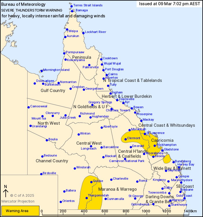
For people in parts of Central Coast and Whitsundays, Central
Highlands and Coalfields, Channel Country, Capricornia, Wide Bay
and Burnett and Maranoa and Warrego Forecast Districts.
Issued at 7:02 pm Sunday, 9 March 2025.
LOCALLY INTENSE RAINFALL POSSIBLE IN WIDE BAY AND BURNETT.
Weather Situation: Slow-moving storms in an extremely moist
atmosphere are continuing to produce heavy rainfall across parts of
the Capricornia and Wide Bay and Burnett. Further inland in the
Channel Country and Maranoa and Warrego gusty severe thunderstorms
have developed.
VERY DANGEROUS THUNDERSTORMS are likely to produce heavy, possibly
LOCALLY INTENSE RAINFALL that may lead to dangerous and
life-threatening flash flooding over the next several hours in
parts of the Wide Bay and Burnett and Capricornia districts.
Locations which may be affected include Miriam Vale and Seventeen
Seventy.
Severe thunderstorms are likely to produce heavy rainfall that may
lead to flash flooding over the next several hours in parts of the
Central Coast and Whitsundays, Central Highlands and Coalfields and
Capricornia districts. Locations which may be affected include
Rockhampton, Clermont, Yeppoon, Marlborough, St Lawrence, Capella,
Dysart, Duaringa, Byfield and Mount Morgan.
Severe thunderstorms are likely to produce damaging winds over the
next several hours in parts of the Channel Country and Maranoa and
Warrego districts. Locations which may be affected include
Thargomindah, Quilpie, Hungerford and Eulo.
A separate Severe Weather Warning for heavy rainfall, locally
intense rainfall remains current over Southeast Coast and parts of
Wide Bay and Burnett and Darling Downs and Granite Belt Forecast
Districts. Please refer to http://www.bom.gov.au/warnings/
Significant observations:
105 mm WAS RECORDED AT FRED HAIGH HIGHWAY IN THE 1 HOUR TO 2:41
PM.
250 mm WAS RECORDED AT HERVEY BAY IN THE 6 HOURS TO 11:30
AM.
204 mm WAS RECORDED AT GHOST HILL IN THE 6 HOURS TO 11:41
AM.
72 mm was recorded at Bucca Weir Highway in the 1 hour to 1:32
pm.
108 mm was recorded at Hermans Gully (Bucca Rd) in the 2 hours to
1:35 pm.
78 mm was recorded at Pine Creek (Pine Creek Road) in the 1 hour
to 12:09 pm.
111 km/h wind gust was recorded at Thargomindah at 5:07 pm.
Emergency services advise people to:
* If you have children make sure they are with you or an adult you
trust.
* Park your car undercover away from trees.
* Close doors and windows.
* Keep asthma medications close by. Storms and wind can trigger
asthma attacks.
* Charge mobile phones and power banks in case the power goes
out.
* Put your pets somewhere safe and make sure they can be
identified in case they get lost.
* Do not drive now unless you have to because conditions are
dangerous.
* Tell friends, family and neighbours in the area.
* Go inside a strong building now. Stay inside until the storm has
passed.
09/Mar/2025 09:08 AM

